IMAGES TAKEN NEAR TO
Clifford, HEREFORD, HR3 5HL
Introduction
This page details the photographs taken nearby to HR3 5HL by members of the Geograph project.
The Geograph project started in 2005 with the aim of publishing, organising and preserving representative images for every square kilometre of Great Britain, Ireland and the Isle of Man.

There are currently over 7.5m images from over14,400 individuals and you can help contribute to the project by visiting https://www.geograph.org.uk
Image Map
Images are licensed for reuse under creativecommons.org/licenses/by-sa/2.0
Notes
- Clicking on the map will re-center to the selected point.
- The higher the marker number, the further away the image location is from the centre of the postcode.
Image Listing (11 Images Found)
Images are licensed for reuse under creativecommons.org/licenses/by-sa/2.0
Image
Details
Distance
1

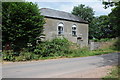
Former Methodist Chapel, Clifford
Now on the market with a local estate agent this methodist chapel dates from 1827.
Image: © Philip Halling
Taken: 25 Jun 2006
0.07 miles
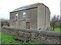
2
Former Calvinistic Methodist chapel
When I photographed this former Calvinistic Methodist chapel in 2006 Image] it was on the market, seven years later, the for sale sign has gone but it shows no sign that it has been sold. The chapel dates from 1827.
Image: © Philip Halling
Taken: 20 Jul 2013
0.11 miles
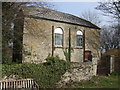
3
Former Methodist Chapel (Clifford)
Sadly couldn't get closer, but the building really has changed a lot since Philip Halling's photo from 2013: Image . The building is now whitewashed, and the entrance gates have two pumpkins on top!
Image: © Fabian Musto
Taken: 19 Oct 2019
0.11 miles
4
Old chapel
Going the way of nearly all such buildings.
Image: © Jeremy Bolwell
Taken: 9 Apr 2012
0.12 miles
5
Former Methodist Chapel at Clifford
Image: © Jonathan Billinger
Taken: 26 Mar 2007
0.14 miles
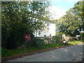
6
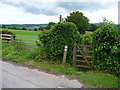
Footpath and gate
On the edge of some houses.
Image: © Jeremy Bolwell
Taken: 17 Jun 2012
0.19 miles
7
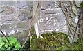
Ordnance Survey Cut Mark
This OS cut mark can be found on the Parish Rooms. It marks a point 165.848m above mean sea level.
Image: © Adrian Dust
Taken: 24 Mar 2017
0.19 miles
8
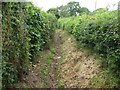
Footpath near Clifford
On the edge of a small housing development.
Image: © Jeremy Bolwell
Taken: 17 Jun 2012
0.20 miles
9
House opposite Clifford church
Presumably this house opposite Clifford church used to be the rectory.
Image: © Philip Halling
Taken: 20 Jul 2013
0.22 miles
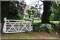
10
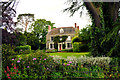
The Old Rectory, Clifford
A delightful late Georgian rectory of 1808.
Image: © Philip Pankhurst
Taken: 26 May 2014
0.22 miles