IMAGES TAKEN NEAR TO
Clifford, HEREFORD, HR3 5HB
Introduction
This page details the photographs taken nearby to HR3 5HB by members of the Geograph project.
The Geograph project started in 2005 with the aim of publishing, organising and preserving representative images for every square kilometre of Great Britain, Ireland and the Isle of Man.

There are currently over 7.5m images from over14,400 individuals and you can help contribute to the project by visiting https://www.geograph.org.uk
Image Map
Images are licensed for reuse under creativecommons.org/licenses/by-sa/2.0
Notes
- Clicking on the map will re-center to the selected point.
- The higher the marker number, the further away the image location is from the centre of the postcode.
Image Listing (5 Images Found)
Images are licensed for reuse under creativecommons.org/licenses/by-sa/2.0
Image
Details
Distance
1
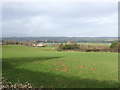
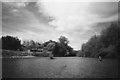
St Oswald's
The view over pasture to the named farm overlooking the River Wye in flood.
Image: © Jonathan Billinger
Taken: 19 Jan 2007
0.03 miles
2
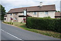
The Castlefield
The Castlefield is an inn beside the B4352 at St Oswald's.
Image: © Philip Halling
Taken: 20 Jul 2013
0.09 miles
3
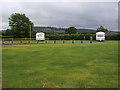
Caravan Park
Caravan park at The Castlefield St Oswald
Image: © Shaun Ferguson
Taken: 23 Jun 2013
0.10 miles
4
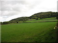
Farmland below Merbach Hill
Taken from the Wye Valley Walk. Merbach Hill itself is well wooded.
Image: © David Purchase
Taken: 17 Oct 2013
0.14 miles
5
Canoeists on the Wye at Clock Mills
Clock Mills is the house in the left background. Taken with a Pentax ME from a canoe. Taking pictures from a canoe you're supposed to be driving is actually quite difficult!
Image: © John Winder
Taken: 14 Jun 2015
0.22 miles