IMAGES TAKEN NEAR TO
Clifford, HEREFORD, HR3 5ET
Introduction
This page details the photographs taken nearby to HR3 5ET by members of the Geograph project.
The Geograph project started in 2005 with the aim of publishing, organising and preserving representative images for every square kilometre of Great Britain, Ireland and the Isle of Man.

There are currently over 7.5m images from over14,400 individuals and you can help contribute to the project by visiting https://www.geograph.org.uk
Image Map
Images are licensed for reuse under creativecommons.org/licenses/by-sa/2.0
Notes
- Clicking on the map will re-center to the selected point.
- The higher the marker number, the further away the image location is from the centre of the postcode.
Image Listing (4 Images Found)
Images are licensed for reuse under creativecommons.org/licenses/by-sa/2.0
Image
Details
Distance
1
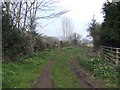
Track onto the Wye floodplain
North of Clifford
Image: © Jonathan Billinger
Taken: 26 Mar 2007
0.12 miles
2
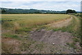
Wheatfield near Clifford
A field of wheat between the road and the course of the defunct railway at Clifford.
Image: © Philip Halling
Taken: 20 Jul 2013
0.13 miles