IMAGES TAKEN NEAR TO
Forest Road, HEREFORD, HR3 5DX
Introduction
This page details the photographs taken nearby to Forest Road, HR3 5DX by members of the Geograph project.
The Geograph project started in 2005 with the aim of publishing, organising and preserving representative images for every square kilometre of Great Britain, Ireland and the Isle of Man.

There are currently over 7.5m images from over14,400 individuals and you can help contribute to the project by visiting https://www.geograph.org.uk
Image Map
Images are licensed for reuse under creativecommons.org/licenses/by-sa/2.0
Notes
- Clicking on the map will re-center to the selected point.
- The higher the marker number, the further away the image location is from the centre of the postcode.
Image Listing (312 Images Found)
Images are licensed for reuse under creativecommons.org/licenses/by-sa/2.0
Image
Details
Distance
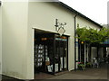
2
Forest Road, Hay-on-Wye
Forest Road heads away from the B4350 at about the point where Church Road becomes Brecon Road. The sign on the left shows 8 miles to Capel-y-ffin (unsuitable for coaches).
Image: © Jaggery
Taken: 30 Jun 2010
0.06 miles
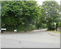
3
Castle Gardens, Forest Road, Hay-on-Wye
View from Forest Road, Hay-on-Wye looking east towards Castle Gardens. A cul-de-sac built in the 1970's. This area used to be the walled gardens for Hay Castle.
Image: © Eric Pugh
Taken: 6 May 2011
0.06 miles
4
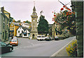
Clock Tower, Hay-on-Wye.
An unusually quiet moment in the middle of this Welsh border town which is famous for its number of bookshops.
Image: © Colin Smith
Taken: Unknown
0.08 miles
5
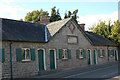
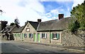
Almshouses, Hay-on-Wye
A row of almshouses erected and endowed by Frances Harley, 1832 'for the reception of 6 poor, indigent women'.
Image: © Jim Barton
Taken: 20 Sep 2009
0.08 miles
6
The Swan at Hay, Hay-on-Wye
Located on the corner of Church Street and Swan Bank, The Swan at Hay is a restaurant and hotel.
The Grade II listed building is a former Georgian coaching inn.
Image: © Jaggery
Taken: 30 Jun 2010
0.08 miles
7
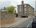
De Breos Court, Hay-on-Wye
Viewed from the Church Street end. The street is named after the de Breos family.
The Hay-on-Wye tourist board website states
"William de Breos II, one of the most infamously treacherous of the Norman Marcher Lords, built the present castle http://www.geograph.org.uk/photo/61858 c1200".
Image: © Jaggery
Taken: 30 Jun 2010
0.08 miles
8
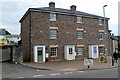
21-23 De Breos Court, Hay-On-Wye
Located in Church Street, these three houses are part of De Breos Court, most of which is around the corner out of shot on the right. Number 23 De Breos Court is on the left.
De Breos Court, is named after the de Breos family. The Hay-on-Wye tourist board website states
"William de Breos II, one of the most infamously treacherous of the Norman Marcher Lords, built the present castle http://www.geograph.org.uk/photo/61858 c1200".
Image: © Jaggery
Taken: 10 Jun 2012
0.08 miles
9
Harley Almshouse, Hay-on-Wye
For indigent females and dating from 1822.
Image: © Philip Pankhurst
Taken: 26 Sep 2011
0.08 miles
10
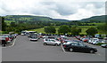
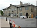
Nearly full main car park, Hay-on-Wye
Viewed from the Oxford Road entrance.
There are few available parking spaces here today, Sunday June 10th, 2012, the final day of the annual Hay Festival which this year started on May 31st. Many fields in the area have been in use as temporary car parks during the festival.
Image: © Jaggery
Taken: 10 Jun 2012
0.08 miles