IMAGES TAKEN NEAR TO
Clehonger, HEREFORD, HR2 9TG
Introduction
This page details the photographs taken nearby to HR2 9TG by members of the Geograph project.
The Geograph project started in 2005 with the aim of publishing, organising and preserving representative images for every square kilometre of Great Britain, Ireland and the Isle of Man.

There are currently over 7.5m images from over14,400 individuals and you can help contribute to the project by visiting https://www.geograph.org.uk
Image Map
Images are licensed for reuse under creativecommons.org/licenses/by-sa/2.0
Notes
- Clicking on the map will re-center to the selected point.
- The higher the marker number, the further away the image location is from the centre of the postcode.
Image Listing (12 Images Found)
Images are licensed for reuse under creativecommons.org/licenses/by-sa/2.0
Image
Details
Distance
1
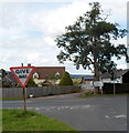
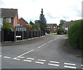
Junction of the B4349 and B4352 in Clehonger
Though traffic on the camera side, on the B4349, has to give way to traffic on the B4352, this point marks the eastern end of the B4352. The road on the right, to Hereford, is the B4349. Signs show 4 (miles) to Hereford, and in the opposite direction 2 to Madley, 6 to Blakemere and 9 to Bredwardine.
Image: © Jaggery
Taken: 26 Aug 2012
0.11 miles
2
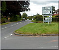
Distances from Clehonger
The course of the B4349 turns through 90 degrees here, at the junction with the B4352 which ends here. Distances shown along the B4349 are 4 (miles) to Hereford (eastwards). Southwards, it's 2 to Kingstone, 7 to Peterchurch and 16 to Hay-on-Wye.
Image: © Jaggery
Taken: 26 Aug 2012
0.12 miles
3
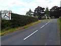
B4349 approaches B4352 junction in Clehonger
Located at the northern edge of the village.
Image: © Jaggery
Taken: 26 Aug 2012
0.12 miles
4
Croft Road bus stop and shelter, Clehonger
Viewed from the corner of the B4349.
Image: © Jaggery
Taken: 26 Aug 2012
0.15 miles
5
Footpath to Cagebrook Bridge
Stile north of the B4349 west of Clehonger.
Image: © Jonathan Billinger
Taken: 31 Jul 2008
0.17 miles
6
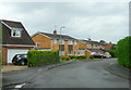
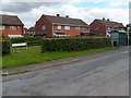
Village housing, Clehonger
A dormitary village for Hereford, this cul-de-sac is Syers Croft.
Image: © Jonathan Billinger
Taken: 31 Jul 2008
0.18 miles
7
Birch Meadow, Clehonger
A residential cul-de-sac viewed from Gosmore Road.
Image: © Jaggery
Taken: 26 Aug 2012
0.21 miles
8
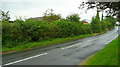
B4349 at Clehonger
Looking towards the village centre and Hereford, from the Poplar Road junction.
In a sudden rain shower!
Image: © Jonathan Billinger
Taken: 31 Jul 2008
0.21 miles
9
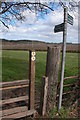
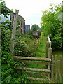
Stile and footpath signs, Clehonger
Footpaths to Ruckhall and Abbey Farm
Image: © Philip Halling
Taken: 8 Apr 2006
0.23 miles
10
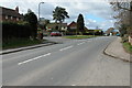
The B4349 passing through Clehonger
The B4349 through Clehonger
Image: © Philip Halling
Taken: 8 Apr 2006
0.23 miles