IMAGES TAKEN NEAR TO
Gardiners Oak, HEREFORD, HR2 9SZ
Introduction
This page details the photographs taken nearby to Gardiners Oak, HR2 9SZ by members of the Geograph project.
The Geograph project started in 2005 with the aim of publishing, organising and preserving representative images for every square kilometre of Great Britain, Ireland and the Isle of Man.

There are currently over 7.5m images from over14,400 individuals and you can help contribute to the project by visiting https://www.geograph.org.uk
Image Map
Images are licensed for reuse under creativecommons.org/licenses/by-sa/2.0
Notes
- Clicking on the map will re-center to the selected point.
- The higher the marker number, the further away the image location is from the centre of the postcode.
Image Listing (13 Images Found)
Images are licensed for reuse under creativecommons.org/licenses/by-sa/2.0
Image
Details
Distance
1
Poplar Road postbox, Clehonger
Located near the B4349 junction. Alongside the postbox are a notice board and a Thieves Beware notice. A Neighbourhood Watch sign is on the opposite side of the road.
Image: © Jaggery
Taken: 26 Aug 2012
0.09 miles
2
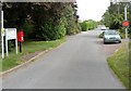
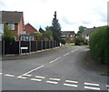
B4349 at Clehonger
Looking towards the village centre and Hereford, from the Poplar Road junction.
In a sudden rain shower!
Image: © Jonathan Billinger
Taken: 31 Jul 2008
0.10 miles
3
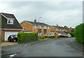
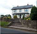
Village housing, Clehonger
A dormitary village for Hereford, this cul-de-sac is Syers Croft.
Image: © Jonathan Billinger
Taken: 31 Jul 2008
0.11 miles
4
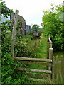
Footpath to Cagebrook Bridge
Stile north of the B4349 west of Clehonger.
Image: © Jonathan Billinger
Taken: 31 Jul 2008
0.15 miles
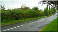
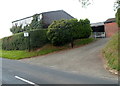
5
Bowley B&B, Clehonger
Bed & breakfast accommodation located alongside the B4349 in the west of Clehonger.
Image: © Jaggery
Taken: 26 Aug 2012
0.15 miles
6
Croft Road bus stop and shelter, Clehonger
Viewed from the corner of the B4349.
Image: © Jaggery
Taken: 26 Aug 2012
0.16 miles
7
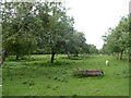
A Clehonger orchard
Viewed from a gate alongside the B4349.
Image: © Jaggery
Taken: 26 Aug 2012
0.16 miles
8
Cattle chiropodist, Clehonger
The sign alongside the B4349 shows Cattle Chiropodist.
Image: © Jaggery
Taken: 26 Aug 2012
0.19 miles
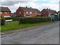
9
Birch Meadow, Clehonger
A residential cul-de-sac viewed from Gosmore Road.
Image: © Jaggery
Taken: 26 Aug 2012
0.20 miles
10
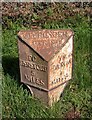
Old Milestone, B4349, near Bowley Farm, Clehonger
The milestone is located on the verge, on the north side of the road. Parish of Clehonger (Herefordshire District). Cast iron post, Hereford iron T-post design, erected by the Hereford turnpike trust in the 19th century.
Inscription reads:-
TO / HEREFORD / 5 / MILES : : CLEHONGER / PARISH : : TO / PETERCHUrch / 7 / MILES
Milestone Society National ID: HF_HFPC05
Image: © M Faherty
Taken: 17 Mar 2008
0.20 miles