IMAGES TAKEN NEAR TO
Merryhill Park, HEREFORD, HR2 9SS
Introduction
This page details the photographs taken nearby to Merryhill Park, HR2 9SS by members of the Geograph project.
The Geograph project started in 2005 with the aim of publishing, organising and preserving representative images for every square kilometre of Great Britain, Ireland and the Isle of Man.

There are currently over 7.5m images from over14,400 individuals and you can help contribute to the project by visiting https://www.geograph.org.uk
Image Map
Images are licensed for reuse under creativecommons.org/licenses/by-sa/2.0
Notes
- Clicking on the map will re-center to the selected point.
- The higher the marker number, the further away the image location is from the centre of the postcode.
Image Listing (13 Images Found)
Images are licensed for reuse under creativecommons.org/licenses/by-sa/2.0
Image
Details
Distance
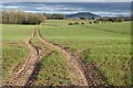
2
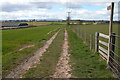
Footpath and track at Merry Hill
View to the west from Merry Hill, along a track and footpath. Hay Bluff can be seen on the horizon; it is at the northern end of the Black Mountains where the scarp falls to Hay-on-Wye.
Image: © Philip Halling
Taken: 8 Apr 2006
0.10 miles
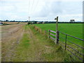
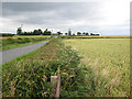
3
Byway to Grafton
Looking east from the Haywood road at Merry Hill.
Image: © Jonathan Billinger
Taken: 7 Aug 2008
0.10 miles
4
Footpath west to Clehonger
View from the Haywood Road at Merry Hill.
Image: © Jonathan Billinger
Taken: 7 Aug 2008
0.15 miles
5
Arable farmland
Arable farmland near Merryhill Farm. Dinedor Hill can be seen in the distance.
Image: © Philip Halling
Taken: 1 Feb 2022
0.18 miles
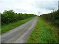
6
Heading for SW Hereford
Along a country road near Merryhill Farm.
Image: © Pauline E
Taken: 18 Jul 2008
0.19 miles
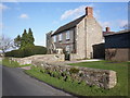
7
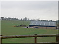
Barns at Merryhill Farm
South of Hereford.
Image: © Eirian Evans
Taken: 15 Feb 2011
0.20 miles
8
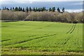
Field of winter cereals
Field of winter cereals with Hayleasow Wood beyond.
Image: © Philip Halling
Taken: 1 Feb 2022
0.21 miles
9
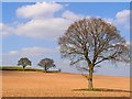
Herefordshire Countryside
A few lone trees allowed to stand in a field.
Image: © Stuart Wilding
Taken: 11 Apr 2007
0.22 miles
10
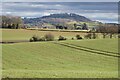
Dinedor Hill
Dinedor Hill viewed across farmland near Grafton.
Image: © Philip Halling
Taken: 1 Feb 2022
0.23 miles