IMAGES TAKEN NEAR TO
Northamfield, HEREFORD, HR2 9SR
Introduction
This page details the photographs taken nearby to Northamfield, HR2 9SR by members of the Geograph project.
The Geograph project started in 2005 with the aim of publishing, organising and preserving representative images for every square kilometre of Great Britain, Ireland and the Isle of Man.

There are currently over 7.5m images from over14,400 individuals and you can help contribute to the project by visiting https://www.geograph.org.uk
Image Map
Images are licensed for reuse under creativecommons.org/licenses/by-sa/2.0
Notes
- Clicking on the map will re-center to the selected point.
- The higher the marker number, the further away the image location is from the centre of the postcode.
Image Listing (5 Images Found)
Images are licensed for reuse under creativecommons.org/licenses/by-sa/2.0
Image
Details
Distance
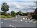
1
Birch Meadow, Clehonger
A residential cul-de-sac viewed from Gosmore Road.
Image: © Jaggery
Taken: 26 Aug 2012
0.17 miles
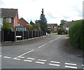
2
Birch Hill Road, Clehonger
A view SSE across Gosmore Road. Something has bent the street name sign on the right such that only BIRCH H is visible in this view.
Image: © Jaggery
Taken: 26 Aug 2012
0.17 miles
3
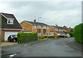
Village housing, Clehonger
A dormitary village for Hereford, this cul-de-sac is Syers Croft.
Image: © Jonathan Billinger
Taken: 31 Jul 2008
0.22 miles
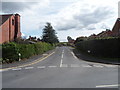
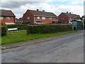
4
Intersection of Gosmore Road and Birch Hill Road, Clehonger
Viewed along Gosmore Road across Birch Hill Road.
Image: © Jaggery
Taken: 26 Aug 2012
0.22 miles
5
Croft Road bus stop and shelter, Clehonger
Viewed from the corner of the B4349.
Image: © Jaggery
Taken: 26 Aug 2012
0.22 miles