
IMAGES TAKEN NEAR TO
Madley, HEREFORD, HR2 9PN
Introduction
This page details the photographs taken nearby to HR2 9PN by members of the Geograph project.
The Geograph project started in 2005 with the aim of publishing, organising and preserving representative images for every square kilometre of Great Britain, Ireland and the Isle of Man.

There are currently over 7.5m images from over14,400 individuals and you can help contribute to the project by visiting https://www.geograph.org.uk
Image Map
Images are licensed for reuse under creativecommons.org/licenses/by-sa/2.0
Notes
- Clicking on the map will re-center to the selected point.
- The higher the marker number, the further away the image location is from the centre of the postcode.
Image Listing (5 Images Found)
Images are licensed for reuse under creativecommons.org/licenses/by-sa/2.0
Image
Details
Distance
1
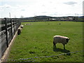
Madley, sheep
Sheltering next to Hillview House.
Image: © Mike Faherty
Taken: 8 Apr 2010
0.03 miles
2
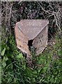
Old Milepost by the B4352, near Showel Farm, Madley parish
Cast iron post by the B4352, in parish of MADLEY (District), Showel Farm; opposite nursery, on the verge, on North side of road. Hereford iron T-post, erected by the Hereford turnpike trust in the 19th century. Broken.
Inscription reads:-
: TO / HEREFO(RD) / 7 / MILES : : MADLEY / PARISH : : TO / HAY / 15 / (M)ILES :
Herefordshire SMR listed.
SMR Number: 56669 https://www.heritagegateway.org.uk/Gateway/Results_Single.aspx?uid=MHE28425&resourceID=101
Milestone Society National ID: HF_HYHF15.
Image: © M Faherty
Taken: 8 Apr 2010
0.06 miles
3
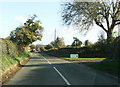
Approach to Madley
Approaching Madley on the B4352, adjacent to the Danmek Nursery
Image: © Alan Spencer
Taken: 5 Nov 2009
0.10 miles
5
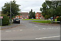
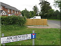
Tinglebrook Close, Madley
Tinglebrook Close is a cul-de-sac of 19 houses on the north side of the B4352.
A faded sign on the left shows
PRIVATE
RESIDENTS
ONLY.
Image: © Jaggery
Taken: 2 Sep 2012
0.23 miles