IMAGES TAKEN NEAR TO
Vowchurch, HEREFORD, HR2 9PF
Introduction
This page details the photographs taken nearby to HR2 9PF by members of the Geograph project.
The Geograph project started in 2005 with the aim of publishing, organising and preserving representative images for every square kilometre of Great Britain, Ireland and the Isle of Man.

There are currently over 7.5m images from over14,400 individuals and you can help contribute to the project by visiting https://www.geograph.org.uk
Image Map
Images are licensed for reuse under creativecommons.org/licenses/by-sa/2.0
Notes
- Clicking on the map will re-center to the selected point.
- The higher the marker number, the further away the image location is from the centre of the postcode.
Image Listing (11 Images Found)
Images are licensed for reuse under creativecommons.org/licenses/by-sa/2.0
Image
Details
Distance
2
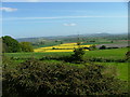
View North from Batchy Hill
Spring scene, rape in full bloom.
Image: © Alan Spencer
Taken: 11 May 2009
0.03 miles
3
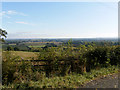
View Northwest from Batchy Hill.
Blue sky view.
Image: © Alan Spencer
Taken: 29 Sep 2009
0.04 miles
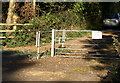
4
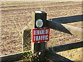
Footpath warning
Health and safety sign.
Image: © Alan Spencer
Taken: 29 Sep 2009
0.06 miles
5
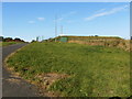
Underground reservoir
Madley's water supply.
Image: © Alan Spencer
Taken: 29 Sep 2009
0.06 miles
7
Road to Batchy Hill Reservoir
A private drive.
Image: © Jonathan Billinger
Taken: 23 Dec 2015
0.13 miles
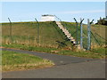
8
Gateway to Waterworks
Gate and Cattle grid
Image: © Alan Spencer
Taken: 29 Sep 2009
0.15 miles
9
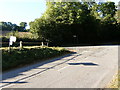
Batchy Hill junction with the B4348
Blind road junction.
Image: © Alan Spencer
Taken: 29 Sep 2009
0.17 miles
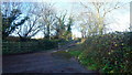
10
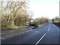
Fork in the road on Batchy Hill
Left goes to Madley, right to Kingstone on the B4348.
Image: © Jonathan Billinger
Taken: 19 Jan 2007
0.18 miles