IMAGES TAKEN NEAR TO
Madley, HEREFORD, HR2 9PE
Introduction
This page details the photographs taken nearby to HR2 9PE by members of the Geograph project.
The Geograph project started in 2005 with the aim of publishing, organising and preserving representative images for every square kilometre of Great Britain, Ireland and the Isle of Man.

There are currently over 7.5m images from over14,400 individuals and you can help contribute to the project by visiting https://www.geograph.org.uk
Image Map
Images are licensed for reuse under creativecommons.org/licenses/by-sa/2.0
Notes
- Clicking on the map will re-center to the selected point.
- The higher the marker number, the further away the image location is from the centre of the postcode.
Image Listing (3 Images Found)
Images are licensed for reuse under creativecommons.org/licenses/by-sa/2.0
Image
Details
Distance
1
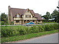
Modern house near Brampton
Attractive part timber built modern house on the road between Brampton and Shenmore.
Image: © Philip Halling
Taken: 31 Jul 2010
0.01 miles
3
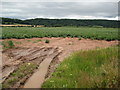
Field of potatoes near Brampton
View across a field of potatoes with Timberline Wood in the background.
Image: © Philip Halling
Taken: 31 Jul 2010
0.14 miles