IMAGES TAKEN NEAR TO
Bullstall Lane, HEREFORD, HR2 9LY
Introduction
This page details the photographs taken nearby to Bullstall Lane, HR2 9LY by members of the Geograph project.
The Geograph project started in 2005 with the aim of publishing, organising and preserving representative images for every square kilometre of Great Britain, Ireland and the Isle of Man.

There are currently over 7.5m images from over14,400 individuals and you can help contribute to the project by visiting https://www.geograph.org.uk
Image Map
Images are licensed for reuse under creativecommons.org/licenses/by-sa/2.0
Notes
- Clicking on the map will re-center to the selected point.
- The higher the marker number, the further away the image location is from the centre of the postcode.
Image Listing (6 Images Found)
Images are licensed for reuse under creativecommons.org/licenses/by-sa/2.0
Image
Details
Distance
1
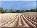
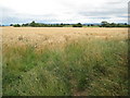
Ploughed Field
Looking South East from Brampton Road. Little Brampton.
Image: © Alan Spencer
Taken: 5 May 2008
0.15 miles
3
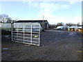
Lawnsdown Nurseries
This horticultural unit is owned by Wyevale Nurseries (not the Garden Centres) as an extra facility for growing trees and shrubs for wholesale.
Image: © Jonathan Billinger
Taken: 19 Jan 2007
0.18 miles
4
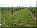
Apple trees at Little Brampton
One of a number of recently planted apple orchards in this area.
Image: © Philip Halling
Taken: 31 Jul 2010
0.23 miles
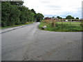
6
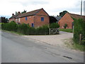
Farm at Little Brampton
Farm near a road junction at Little Brampton.
Image: © Philip Halling
Taken: 31 Jul 2010
0.25 miles