IMAGES TAKEN NEAR TO
Kingstone, HEREFORD, HR2 9HQ
Introduction
This page details the photographs taken nearby to HR2 9HQ by members of the Geograph project.
The Geograph project started in 2005 with the aim of publishing, organising and preserving representative images for every square kilometre of Great Britain, Ireland and the Isle of Man.

There are currently over 7.5m images from over14,400 individuals and you can help contribute to the project by visiting https://www.geograph.org.uk
Image Map
Images are licensed for reuse under creativecommons.org/licenses/by-sa/2.0
Notes
- Clicking on the map will re-center to the selected point.
- The higher the marker number, the further away the image location is from the centre of the postcode.
Image Listing (13 Images Found)
Images are licensed for reuse under creativecommons.org/licenses/by-sa/2.0
Image
Details
Distance
1
Kingstone - Kingstone and Thruxton Primary School
Situated on the B4349. Kingstone High School is about 300 yards to the north-east.
Image: © Tony Bailey
Taken: 11 May 2006
0.02 miles
2
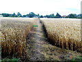
Public footpath through the crops, Kingstone
There is a metre wide gap in the crops along a public footpath through a field.
Viewed from the edge of the B4348.
Image: © Jaggery
Taken: 26 Aug 2012
0.06 miles
3
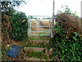
Steps up to a path through crops, Kingstone
Viewed from the B4348.
The steps lead up to a gate giving access to a public footpath through crops. http://www.geograph.org.uk/photo/3102396
Image: © Jaggery
Taken: 26 Aug 2012
0.12 miles
4
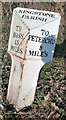
Old Milepost by the B4348, west of Kingstone
Cast iron post by the B4348, in parish of Kingstone (District), Hanley Court, on wider verge by oak tree, on Northeast side of road. Hereford iron T-post, erected by the Clifford to Dewchurch turnpike trust in the 19th century.
Inscription reads:-
: TO / ROSS / 15 / MILES : : KINGSTONE / PARISH : : TO / PETERCHUrch / 5 / MILES :
Herefordshire SMR.
SMR Number: 56764 https://www.heritagegateway.org.uk/Gateway/Results_Single.aspx?uid=MHE28519&resourceID=101
Milestone Society National ID: HF_RSPC15
Image: © Robert Walker
Taken: 1 Nov 2011
0.12 miles
5
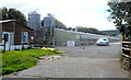
Poultry houses, Gooses Foot Farm, Kingstone
Viewed from the B4348.
Image: © Jaggery
Taken: 26 Aug 2012
0.17 miles
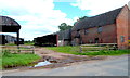
6
Farm building opposite Hanley Court
North of the B4348 at Kingstone.
Image: © Jonathan Billinger
Taken: 19 Jan 2007
0.18 miles
7
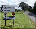
B4348 enters Kingstone
The B4348 enters the Herefordshire village of Kingstone.
A few metres behind the camera is a left turn into the B4349.
Image: © Jaggery
Taken: 26 Aug 2012
0.19 miles
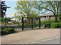
8
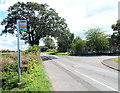
Kingstone bus stop
Located at the western edge of the village, on route 39/39A from Brecon to Hereford.
Image: © Jaggery
Taken: 26 Aug 2012
0.20 miles
9
Hanley Court farm buildings, Kingstone
The B4348 runs through the middle of Hanley Court farm.
These buildings are on the north side of the road.
Image: © Jaggery
Taken: 26 Aug 2012
0.21 miles
10
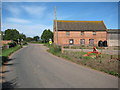
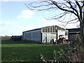
Farm building, Kingstone
Traditional red-brick farm building at Hanley Court in the village of Kingstone.
Image: © Philip Halling
Taken: 18 Sep 2010
0.21 miles