IMAGES TAKEN NEAR TO
Woodpecker Drive, HEREFORD, HR2 9FG
Introduction
This page details the photographs taken nearby to Woodpecker Drive, HR2 9FG by members of the Geograph project.
The Geograph project started in 2005 with the aim of publishing, organising and preserving representative images for every square kilometre of Great Britain, Ireland and the Isle of Man.

There are currently over 7.5m images from over14,400 individuals and you can help contribute to the project by visiting https://www.geograph.org.uk
Image Map
Images are licensed for reuse under creativecommons.org/licenses/by-sa/2.0
Notes
- Clicking on the map will re-center to the selected point.
- The higher the marker number, the further away the image location is from the centre of the postcode.
Image Listing (11 Images Found)
Images are licensed for reuse under creativecommons.org/licenses/by-sa/2.0
Image
Details
Distance
1
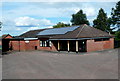
Village Hall, Clehonger
Set back 60 metres from the east side of Birch Hill Road, near the B4349.
Image: © Jaggery
Taken: 26 Aug 2012
0.09 miles
2
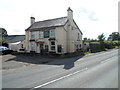
The Seven Stars near Clehonger
Viewed across the B4349.
The pub has a Petanque Club and an outdoor area http://www.geograph.org.uk/photo/3646411 where French boules can be played.
Image: © Jaggery
Taken: 26 Aug 2012
0.10 miles
3

Petanque and boules area outside The Seven Stars, Clehonger
On the east side of this pub. http://www.geograph.org.uk/photo/3646392
Image: © Jaggery
Taken: 26 Aug 2012
0.12 miles
4
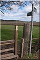
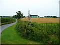
Stile and footpath signs, Clehonger
Footpaths to Ruckhall and Abbey Farm
Image: © Philip Halling
Taken: 8 Apr 2006
0.14 miles
5
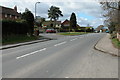
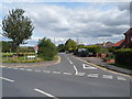
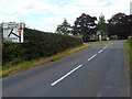
The B4349 passing through Clehonger
The B4349 through Clehonger
Image: © Philip Halling
Taken: 8 Apr 2006
0.14 miles
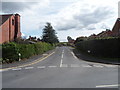
6
Intersection of Gosmore Road and Birch Hill Road, Clehonger
Viewed along Gosmore Road across Birch Hill Road.
Image: © Jaggery
Taken: 26 Aug 2012
0.14 miles
7
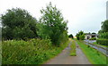
Parallel roads
View south of Gosmore Road, Clehonger, showing the public footpath, left, and private drive, right.
Image: © Jonathan Billinger
Taken: 31 Jul 2008
0.15 miles
8
Footpath off Gosmore Road
Looking east towards Hereford.
Image: © Jonathan Billinger
Taken: 31 Jul 2008
0.17 miles
9
Birch Hill Road, Clehonger
A view SSE across Gosmore Road. Something has bent the street name sign on the right such that only BIRCH H is visible in this view.
Image: © Jaggery
Taken: 26 Aug 2012
0.17 miles
10
B4349 approaches B4352 junction in Clehonger
Located at the northern edge of the village.
Image: © Jaggery
Taken: 26 Aug 2012
0.24 miles