IMAGES TAKEN NEAR TO
Allensmore, HEREFORD, HR2 9BN
Introduction
This page details the photographs taken nearby to HR2 9BN by members of the Geograph project.
The Geograph project started in 2005 with the aim of publishing, organising and preserving representative images for every square kilometre of Great Britain, Ireland and the Isle of Man.

There are currently over 7.5m images from over14,400 individuals and you can help contribute to the project by visiting https://www.geograph.org.uk
Image Map
Images are licensed for reuse under creativecommons.org/licenses/by-sa/2.0
Notes
- Clicking on the map will re-center to the selected point.
- The higher the marker number, the further away the image location is from the centre of the postcode.
Image Listing (7 Images Found)
Images are licensed for reuse under creativecommons.org/licenses/by-sa/2.0
Image
Details
Distance
1
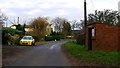
Bus shelter and yellow Rover/MG
Cobhall Common in 2013.
Image: © Jonathan Billinger
Taken: 9 Dec 2013
0.02 miles
2
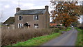
Derelict cottage in Cobhall Common
Five years on from Image and the building cannot now be inhabited.
I'll come back again in 2018, Lord willing!
Image: © Jonathan Billinger
Taken: 9 Dec 2013
0.10 miles
3
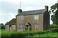
Dilapidated cottage in Cobhall Common
This place has seen better days, but still appears to be inhabited.
Image: © Jonathan Billinger
Taken: 18 Aug 2008
0.10 miles
4
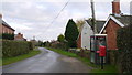
Telephone box and Postbox
Cobhall Common infrastructure in 2013.
Image: © Jonathan Billinger
Taken: 9 Dec 2013
0.12 miles
5
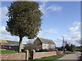
Cobhall Farm
The lollipop shaped tree is a holly.
Image: © Jonathan Billinger
Taken: 26 Feb 2007
0.18 miles
6
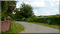
Road to Hereford
Cobhall Farm is to the left.
Image: © Jonathan Billinger
Taken: 20 May 2019
0.18 miles
7
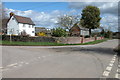
Cobhall Farm, Allensmore
Cobhall Farm is situated on crossroads of lanes.
Image: © Philip Halling
Taken: 8 Apr 2006
0.21 miles