IMAGES TAKEN NEAR TO
Templars Oaks, HEREFORD, HR2 8RW
Introduction
This page details the photographs taken nearby to Templars Oaks, HR2 8RW by members of the Geograph project.
The Geograph project started in 2005 with the aim of publishing, organising and preserving representative images for every square kilometre of Great Britain, Ireland and the Isle of Man.

There are currently over 7.5m images from over14,400 individuals and you can help contribute to the project by visiting https://www.geograph.org.uk
Image Map
Images are licensed for reuse under creativecommons.org/licenses/by-sa/2.0
Notes
- Clicking on the map will re-center to the selected point.
- The higher the marker number, the further away the image location is from the centre of the postcode.
Image Listing (49 Images Found)
Images are licensed for reuse under creativecommons.org/licenses/by-sa/2.0
Image
Details
Distance
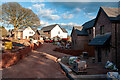
1
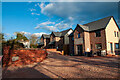
New houses, Garway
New houses have sprung up at either end of Garway in the past couple of years. These are at Templars Oak. Only the one in the distance was occupied when this photo was taken.
Image: © Stuart Wilding
Taken: 5 Apr 2021
0.00 miles
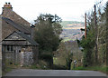
2
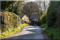
Country Lane, Garway
View looking towards the new houses at Templars Oak.
Image: © Stuart Wilding
Taken: 5 Apr 2021
0.01 miles
3
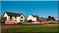
New houses, Garway
New houses have sprung up at either end of Garway in the past couple of years. These are at Templars Oak.
Image: © Stuart Wilding
Taken: 5 Apr 2021
0.01 miles
4
New houses, Garway
New houses have sprung up at either end of Garway in the past couple of years. These are at Templars Oak. Only the one in the distance was occupied when this photo was taken.
Image: © Stuart Wilding
Taken: 5 Apr 2021
0.01 miles
5
New houses, Garway
New houses have sprung up at either end of Garway in the past couple of years. These are at Templars Oak. Only the one in the distance was occupied when this photo was taken.
Image: © Stuart Wilding
Taken: 5 Apr 2021
0.02 miles
6
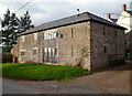
Myrtle Barn, Garway
Former barn converted to residential use.
Image: © Jaggery
Taken: 22 Jan 2012
0.03 miles
7
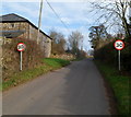
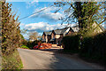
30mph zone in Garway
The National Speed Limit reduces to 30mph alongside Myrtle Barn. http://www.geograph.org.uk/photo/3739853
Image: © Jaggery
Taken: 22 Jan 2012
0.04 miles
9
View West from Garway
Across the Monnow Valley which forms the Welsh/English Border.
Image: © Pauline E
Taken: 27 Feb 2009
0.06 miles
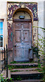
10
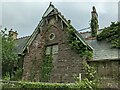
The Old School (Garway)
Built in 1877, this building housed the primary school in Garway for many decades until a new school building was built opposite in 1963. The building has remained derelict since and was threatened with demolition in June 2021 and March 2022.
Image: © Fabian Musto
Taken: 26 May 2022
0.08 miles