IMAGES TAKEN NEAR TO
St. Weonards, HEREFORD, HR2 8PJ
Introduction
This page details the photographs taken nearby to HR2 8PJ by members of the Geograph project.
The Geograph project started in 2005 with the aim of publishing, organising and preserving representative images for every square kilometre of Great Britain, Ireland and the Isle of Man.

There are currently over 7.5m images from over14,400 individuals and you can help contribute to the project by visiting https://www.geograph.org.uk
Image Map
Images are licensed for reuse under creativecommons.org/licenses/by-sa/2.0
Notes
- Clicking on the map will re-center to the selected point.
- The higher the marker number, the further away the image location is from the centre of the postcode.
Image Listing (4 Images Found)
Images are licensed for reuse under creativecommons.org/licenses/by-sa/2.0
Image
Details
Distance
1
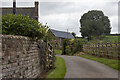
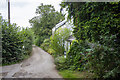
Pendiggott Farm
Vernacular farm building at Pendiggott Farm
Image: © P Gaskell
Taken: Unknown
0.05 miles
2
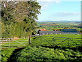
View over Pendiggott
In the distance in this view east over South Herefordshire is the distinctive dome of May Hill.
Image: © Jonathan Billinger
Taken: 10 Nov 2010
0.08 miles
3
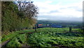
View over Pendiggott, 2015
Not a lot of change since my last photo here in 2010; Image
Image: © Jonathan Billinger
Taken: 4 Dec 2015
0.10 miles