IMAGES TAKEN NEAR TO
Much Birch, HEREFORD, HR2 8HX
Introduction
This page details the photographs taken nearby to HR2 8HX by members of the Geograph project.
The Geograph project started in 2005 with the aim of publishing, organising and preserving representative images for every square kilometre of Great Britain, Ireland and the Isle of Man.

There are currently over 7.5m images from over14,400 individuals and you can help contribute to the project by visiting https://www.geograph.org.uk
Image Map
Images are licensed for reuse under creativecommons.org/licenses/by-sa/2.0
Notes
- Clicking on the map will re-center to the selected point.
- The higher the marker number, the further away the image location is from the centre of the postcode.
Image Listing (11 Images Found)
Images are licensed for reuse under creativecommons.org/licenses/by-sa/2.0
Image
Details
Distance
1
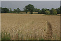
Farmland near Much Birch
Ripening crops seen from Hollybush Lane.
Image: © Stephen McKay
Taken: 31 Jul 2011
0.04 miles
2
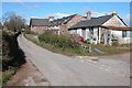
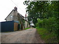
Cottages near Much Birch
These cottages are on a crossroads of lanes to the east of Much Birch, two of the lanes from the crossroads are no through roads.
Image: © Philip Halling
Taken: 8 Apr 2006
0.05 miles
3
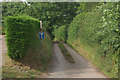
Lane to Strickstenning Hall
Narrow no through road seen from Hollybush Lane.
Image: © Stephen McKay
Taken: 31 Jul 2011
0.05 miles
4
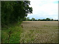
Edge of wheat field
Still awaiting harvest in the wet August of 2008.
Image: © Jonathan Billinger
Taken: 22 Aug 2008
0.15 miles
5
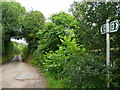
Footpath to the A49
Rather overgrown showing not much use.
The blue boxes are the containers used for Herefordshire's excellent recycling scheme.
Image: © Jonathan Billinger
Taken: 22 Aug 2008
0.17 miles
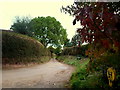
6
Lane and cottage
By the footpath which leads south-west to The Cleaver and the A49.
Image: © Jonathan Billinger
Taken: 22 Aug 2008
0.20 miles
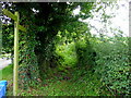
7
Lane and footpath to Bigglestone, 2016
Follow-up photo from my previous visit in 2008; Image
That ash tree may not be there next time I call by here (Chalara Ash Dieback).
The red foliage to the right is that of Liquidambar.
Image: © Jonathan Billinger
Taken: 8 Oct 2016
0.21 miles
8
Lane and footpath to Bigglestone.
The footpaths take over at the end of the public road.
Image: © Jonathan Billinger
Taken: 22 Aug 2008
0.22 miles
9
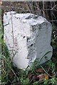
Old Milestone by the A49, Much Birch Parish
Stone post (plate lost) by the A49, in parish of Much Birch (District), "Axe & Cleaver" PH, by bus stop, on West side of road. Hereford iron plate, erected by the Hereford turnpike trust in the 19th century.
Inscription once read:-
(To)
(Hereford)
(7)
(MILES)
Grade II listed.
List Entry Number: 1099580 https://historicengland.org.uk/listing/the-list/list-entry/1099580
Milestone Society National ID: HF_HFRS07
Image: © Simon Clarke
Taken: 25 Apr 2010
0.23 miles
10
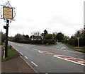
Hollybush Lane, Much Birch
Opposite the Axe & Cleaver, http://www.geograph.org.uk/photo/4309131 Hollybush Lane heads NNE away from the A49, the main road through the village.
Image: © Jaggery
Taken: 1 Jan 2015
0.23 miles