IMAGES TAKEN NEAR TO
Much Birch, HEREFORD, HR2 8HU
Introduction
This page details the photographs taken nearby to HR2 8HU by members of the Geograph project.
The Geograph project started in 2005 with the aim of publishing, organising and preserving representative images for every square kilometre of Great Britain, Ireland and the Isle of Man.

There are currently over 7.5m images from over14,400 individuals and you can help contribute to the project by visiting https://www.geograph.org.uk
Image Map
Images are licensed for reuse under creativecommons.org/licenses/by-sa/2.0
Notes
- Clicking on the map will re-center to the selected point.
- The higher the marker number, the further away the image location is from the centre of the postcode.
Image Listing (7 Images Found)
Images are licensed for reuse under creativecommons.org/licenses/by-sa/2.0
Image
Details
Distance
1
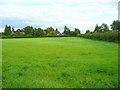
Triangular field
A piece of pasture formed by the junction of Holly Bush Lane with the A49 at Much Birch.
Image: © Jonathan Billinger
Taken: 22 Aug 2008
0.09 miles
3
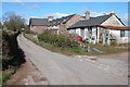
Cottages near Much Birch
These cottages are on a crossroads of lanes to the east of Much Birch, two of the lanes from the crossroads are no through roads.
Image: © Philip Halling
Taken: 8 Apr 2006
0.16 miles
4
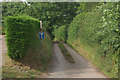
Lane to Strickstenning Hall
Narrow no through road seen from Hollybush Lane.
Image: © Stephen McKay
Taken: 31 Jul 2011
0.16 miles
5
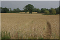
Farmland near Much Birch
Ripening crops seen from Hollybush Lane.
Image: © Stephen McKay
Taken: 31 Jul 2011
0.17 miles
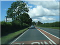
6
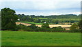
View north-east of Much Birch
Looking from Holly Bush Lane over farmland to Athelstan's Wood.
Image: © Jonathan Billinger
Taken: 22 Aug 2008
0.21 miles
7
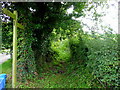
Footpath to the A49
Rather overgrown showing not much use.
The blue boxes are the containers used for Herefordshire's excellent recycling scheme.
Image: © Jonathan Billinger
Taken: 22 Aug 2008
0.23 miles