IMAGES TAKEN NEAR TO
Much Dewchurch, HEREFORD, HR2 8DU
Introduction
This page details the photographs taken nearby to HR2 8DU by members of the Geograph project.
The Geograph project started in 2005 with the aim of publishing, organising and preserving representative images for every square kilometre of Great Britain, Ireland and the Isle of Man.

There are currently over 7.5m images from over14,400 individuals and you can help contribute to the project by visiting https://www.geograph.org.uk
Image Map
Images are licensed for reuse under creativecommons.org/licenses/by-sa/2.0
Notes
- Clicking on the map will re-center to the selected point.
- The higher the marker number, the further away the image location is from the centre of the postcode.
Image Listing (9 Images Found)
Images are licensed for reuse under creativecommons.org/licenses/by-sa/2.0
Image
Details
Distance
4
Stone Bridge over Worm Brook
On the B4348 north of Kivernoll.
Image: © Pauline E
Taken: 7 Oct 2007
0.14 miles
5
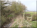
Footpath to Didley
Working its way across the Worm Brook by the B4348 at Kivernoll.
Image: © Jonathan Billinger
Taken: 26 Mar 2007
0.15 miles
6
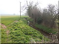
The Worm Brook
View east of the B4348 at Kivernoll.
Image: © Jonathan Billinger
Taken: 26 Mar 2007
0.16 miles
7
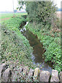
Worm Brook from the Road Bridge
North of Kivernoll on the B4348.
Image: © Pauline E
Taken: 7 Oct 2007
0.16 miles
9
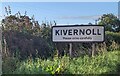
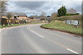
KIVERNOLL - Please drive carefully
The sign is alongside the B4348 at the northern edge of the Herefordshire hamlet.
Kivernoll is part of Much Dewchurch parish.
Image: © Jaggery
Taken: 6 Aug 2023
0.25 miles