IMAGES TAKEN NEAR TO
Much Dewchurch, HEREFORD, HR2 8DT
Introduction
This page details the photographs taken nearby to HR2 8DT by members of the Geograph project.
The Geograph project started in 2005 with the aim of publishing, organising and preserving representative images for every square kilometre of Great Britain, Ireland and the Isle of Man.

There are currently over 7.5m images from over14,400 individuals and you can help contribute to the project by visiting https://www.geograph.org.uk
Image Map
Images are licensed for reuse under creativecommons.org/licenses/by-sa/2.0
Notes
- Clicking on the map will re-center to the selected point.
- The higher the marker number, the further away the image location is from the centre of the postcode.
Image Listing (3 Images Found)
Images are licensed for reuse under creativecommons.org/licenses/by-sa/2.0
Image
Details
Distance
1
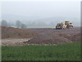
Earthmoving near Kivernoll
The view looks out over the shallow valley of the Worm Brook. The soil is that excavated from a reservoir glimpsed in a forthcoming geograph of this square.
Image: © Jonathan Billinger
Taken: 26 Mar 2007
0.12 miles
2
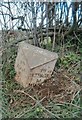
Old Milepost by the B4348, near Top Hill, Much Dewchurch parish
Cast iron post by the B4348, in parish of MUCH DEWCHURCH (District), Southeast of Top Hill, by hedge, on Northeast side of road. Hereford iron T-post, erected by the Clifford to Dewchurch turnpike trust in the 19th century.
Inscription reads:-
: TO / ROSS / 10 / MILES : : DEWCHURCH / PARISH : : TO / PETERCHUrch / 10 / MILES :
Herefordshire SMR.
SMR Number: 56761 https://www.heritagegateway.org.uk/Gateway/Results_Single.aspx?uid=MHE28516&resourceID=101
Milestone Society National ID: HF_RSPC10.
Image: © Robert Walker
Taken: 3 Mar 2012
0.14 miles
3
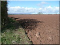
Red soil of Herefordshire
Good quality farmland in this neck o' the woods. In the distance is the ridge of Black Hill/Hay Bluff.
Image: © Jonathan Billinger
Taken: 14 Apr 2008
0.24 miles