IMAGES TAKEN NEAR TO
Barrack Hill, Little Birch, HEREFORD, HR2 8AY
Introduction
This page details the photographs taken nearby to HR2 8AY by members of the Geograph project.
The Geograph project started in 2005 with the aim of publishing, organising and preserving representative images for every square kilometre of Great Britain, Ireland and the Isle of Man.

There are currently over 7.5m images from over14,400 individuals and you can help contribute to the project by visiting https://www.geograph.org.uk
Image Map
Images are licensed for reuse under creativecommons.org/licenses/by-sa/2.0
Notes
- Clicking on the map will re-center to the selected point.
- The higher the marker number, the further away the image location is from the centre of the postcode.
Image Listing (15 Images Found)
Images are licensed for reuse under creativecommons.org/licenses/by-sa/2.0
Image
Details
Distance
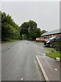
2
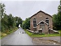
Walking the dog through Little Birch
Phone box on the left, Methodist Church on the right.
Image: © Pauline E
Taken: 22 Jan 2008
0.12 miles
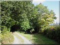
3

Phone box at Little Birch
Just past the village hall.
Image: © Pauline E
Taken: 22 Jan 2008
0.12 miles
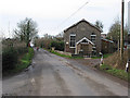
5
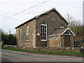
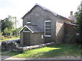
Birch Methodist Church
The stone inscriptions tells us it was the Primitive Methodist Chapel.
Image: © Pauline E
Taken: 22 Jan 2008
0.13 miles
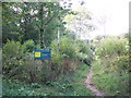
6
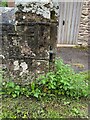
OS Cut Mark - Gatepost, Methodist Church
https://www.bench-marks.org.uk/bm157282
Image: © thejackrustles
Taken: 5 Aug 2021
0.14 miles
7
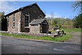
Methodist chapel, Little Birch
Primitive Methodist Chapel in Little Birch dating from 1858 according to Pevsner.
Image: © Philip Halling
Taken: 26 Apr 2014
0.14 miles
8
Primitive Methodist Chapel, King's Thorn
Image: © Roger Cornfoot
Taken: 2 Sep 2011
0.15 miles