IMAGES TAKEN NEAR TO
Ridgehill, HEREFORD, HR2 8AF
Introduction
This page details the photographs taken nearby to HR2 8AF by members of the Geograph project.
The Geograph project started in 2005 with the aim of publishing, organising and preserving representative images for every square kilometre of Great Britain, Ireland and the Isle of Man.

There are currently over 7.5m images from over14,400 individuals and you can help contribute to the project by visiting https://www.geograph.org.uk
Image Map
Images are licensed for reuse under creativecommons.org/licenses/by-sa/2.0
Notes
- Clicking on the map will re-center to the selected point.
- The higher the marker number, the further away the image location is from the centre of the postcode.
Image Listing (7 Images Found)
Images are licensed for reuse under creativecommons.org/licenses/by-sa/2.0
Image
Details
Distance
2
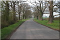
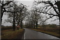
Oak Trees, Green Crize
Avenue of oak trees to the south Green Crize.
Image: © Philip Halling
Taken: 22 Apr 2006
0.14 miles
3
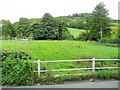
Dinedor Common
Looking east to Dinedor Hill from where the Hereford Road crosses the Red Brook.
Image: © Jonathan Billinger
Taken: 3 Sep 2009
0.14 miles
5
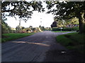
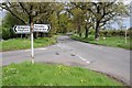
The road to Hoarwithy
The old road between Hereford and Ross on Wye, via Little Dewchurch and Hoarwithy. In the distance, just in front of the house, is the junction with the lane leading to Ridgehill and Twyford Common.
Image: © John Winder
Taken: 29 Jan 2015
0.14 miles
7
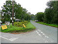
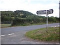
Road to Ross at Dinedor Cross
Looking south along the old through-route from Hereford to Ross-on-Wye via Hoarwithy.
Image: © Jonathan Billinger
Taken: 3 Sep 2009
0.16 miles