IMAGES TAKEN NEAR TO
Wye Street, HEREFORD, HR2 7RB
Introduction
This page details the photographs taken nearby to Wye Street, HR2 7RB by members of the Geograph project.
The Geograph project started in 2005 with the aim of publishing, organising and preserving representative images for every square kilometre of Great Britain, Ireland and the Isle of Man.

There are currently over 7.5m images from over14,400 individuals and you can help contribute to the project by visiting https://www.geograph.org.uk
Image Map
Images are licensed for reuse under creativecommons.org/licenses/by-sa/2.0
Notes
- Clicking on the map will re-center to the selected point.
- The higher the marker number, the further away the image location is from the centre of the postcode.
Image Listing (1620 Images Found)
Images are licensed for reuse under creativecommons.org/licenses/by-sa/2.0
Image
Details
Distance
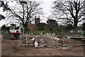
1
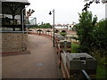
Flood defences and Wye Bridge
The end result of the construction work in progress seen in Image]
Image: © Keith Edkins
Taken: 16 Jul 2013
0.00 miles
2
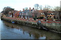
St Stephen's Wharf - Flood defences
Flood wall, it can be raised to the top of the pillars if needed. The south bank of the Wye is very prone to flooding, the Saxon city is on the north for a reason.
Image: © Richard Webb
Taken: 2 May 2015
0.01 miles
3
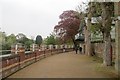
Wye View Villas and a riverside walk, Hereford
The south bank of the River Wye viewed from Wye Bridge.
Image: © Jaggery
Taken: 13 Jan 2012
0.01 miles
4
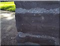
Ordnance Survey Cut Mark
This badly eroded OS cut mark can be found on the building south side of Wye Street. It marks a point 51.258m above mean sea level.
Image: © Adrian Dust
Taken: 10 Mar 2019
0.01 miles
5
Flood Defences Under Construction
Permanent defences on the south side of the River Wye near Riverside Walk and Bishops Meadow.
Image: © Bob Embleton
Taken: 2 Apr 2008
0.01 miles
6
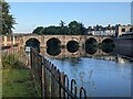
Wye Bridge (Hereford)
The oldest bridge in Hereford was built in 1492, and briefly seen behind it is Greyfriars Bridge which was built in 1966. This bridge spans the River Wye, hence its name.
Image: © Fabian Musto
Taken: 8 Jul 2021
0.01 miles
7
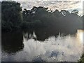
Sunrise over the River Wye (Hereford)
These three swans were swimming in the River Wye when I was looking at the view of Wye Bridge and Left Bank near the tennis courts and centre.
Image: © Fabian Musto
Taken: 8 Jul 2021
0.01 miles
8
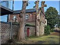
Stable block at Tara House (Hereford)
This stable block was built with Tara House during the early-mid 19th century, and possibly houses a warehouse now.
Image: © Fabian Musto
Taken: 8 Jul 2021
0.01 miles
9
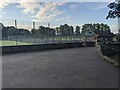
Hereford Tennis Centre
Placed by the Bishop's Meadows and recreational ground is the city tennis centre, which is popular with people who enjoy playing sports and tennis.
Image: © Fabian Musto
Taken: 8 Jul 2021
0.02 miles
10
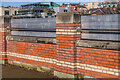
Flood defences
Flood defences in place, protecting Wye View Villas and other properties from flooding of the River Wye, as was the case here with high water levels following Storms Eunice and Franklin. See Image for a photo of the wall with the defences lowered.
Image: © Ian Capper
Taken: 22 Feb 2022
0.02 miles