IMAGES TAKEN NEAR TO
Dulas Avenue, HEREFORD, HR2 7PA
Introduction
This page details the photographs taken nearby to Dulas Avenue, HR2 7PA by members of the Geograph project.
The Geograph project started in 2005 with the aim of publishing, organising and preserving representative images for every square kilometre of Great Britain, Ireland and the Isle of Man.

There are currently over 7.5m images from over14,400 individuals and you can help contribute to the project by visiting https://www.geograph.org.uk
Image Map
Images are licensed for reuse under creativecommons.org/licenses/by-sa/2.0
Notes
- Clicking on the map will re-center to the selected point.
- The higher the marker number, the further away the image location is from the centre of the postcode.
Image Listing (33 Images Found)
Images are licensed for reuse under creativecommons.org/licenses/by-sa/2.0
Image
Details
Distance
2
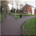
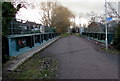
Former railway route, Hereford
The former railway route is a combined footpath and cycleway, part of National Cycle Network route 46.
The right fork leads to Belmont Road.
Image: © Jaggery
Taken: 7 Feb 2017
0.12 miles
3
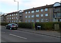
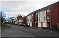
187-221 Belmont Road, Hereford
A 70-metre long row of flats on the south side of Belmont Road.
Image: © Jaggery
Taken: 13 Jan 2012
0.14 miles
4
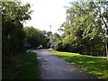
On the old railway track, now a cycle path
Image: © Rob Purvis
Taken: 26 Aug 2015
0.14 miles
5
Recently built houses near Belmont Road, Hereford
Viewed from the edge of The Oval Community Shops http://www.geograph.org.uk/photo/5280243 in February 2017.
Image: © Jaggery
Taken: 7 Feb 2017
0.15 miles
6
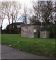
Gas installation on a bank near Belmont Road, Hereford
Alongside National Cycle Network route 46.
Image: © Jaggery
Taken: 7 Feb 2017
0.15 miles
7
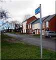
Footpath and cycle route towards Hereford city centre
The small red white and blue sticker on the post shows National Cycle Network route 46.
In February 2017, the Sustrans website states that Route 46 will connect Bromsgrove to Neath when complete.
Image: © Jaggery
Taken: 7 Feb 2017
0.15 miles
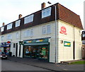
8
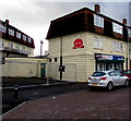
Betfred, The Oval, Hereford
Betting shop at 1 The Oval, on the south side of the A465 Belmont Road.
Image: © Jaggery
Taken: 7 Feb 2017
0.16 miles
9
South across a former railway bridge, Hereford
A combined footpath and cycleway, part of National Cycle Network route 46, crosses this http://www.geograph.org.uk/photo/5280303 bridge over Belmont Road.
Image: © Jaggery
Taken: 7 Feb 2017
0.16 miles
10
Subway, The Oval, Hereford
The Oval is misnamed. Its shape is a semicircle, located on the south side of Belmont Road (A465).
The Subway fast food restaurant and takeaway is located at the end of a row of shops along the straight line of the semicircle. On the left is a post office inside a McColl's store. http://www.geograph.org.uk/photo/2537940
Image: © Jaggery
Taken: 13 Jan 2012
0.17 miles