IMAGES TAKEN NEAR TO
Hillside Avenue, HEREFORD, HR2 7LQ
Introduction
This page details the photographs taken nearby to Hillside Avenue, HR2 7LQ by members of the Geograph project.
The Geograph project started in 2005 with the aim of publishing, organising and preserving representative images for every square kilometre of Great Britain, Ireland and the Isle of Man.

There are currently over 7.5m images from over14,400 individuals and you can help contribute to the project by visiting https://www.geograph.org.uk
Image Map
Images are licensed for reuse under creativecommons.org/licenses/by-sa/2.0
Notes
- Clicking on the map will re-center to the selected point.
- The higher the marker number, the further away the image location is from the centre of the postcode.
Image Listing (56 Images Found)
Images are licensed for reuse under creativecommons.org/licenses/by-sa/2.0
Image
Details
Distance
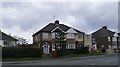
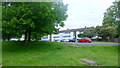
5
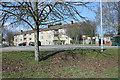
Flats, south Hereford
East facing, across the A49, Ross Road.
Image: © Pauline E
Taken: 7 Mar 2010
0.15 miles
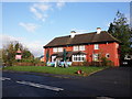
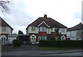
7
Flats in Marlbrook Road, 2
White-rendered social housing facing the Ross Road to the south of Hereford.
Image: © Jonathan Billinger
Taken: 25 Mar 2016
0.16 miles
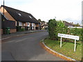
8
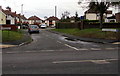
Broadleys Crescent, Hereford
Cul-de-sac on the east side of Ross Road.
Image: © Jaggery
Taken: 7 Feb 2017
0.17 miles
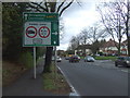
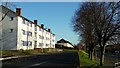
9
Flats in Marlbrook Road, 3
Viewed from the Ross Road, A49.
Image: © Jonathan Billinger
Taken: 23 May 2016
0.17 miles
10
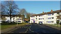
Flats in Marlbrook Road, 1
White-rendered social housing facing the Ross Road to the south of Hereford.
Image: © Jonathan Billinger
Taken: 25 Mar 2016
0.18 miles