
IMAGES TAKEN NEAR TO
Sherborne Close, HEREFORD, HR2 7ET
Introduction
This page details the photographs taken nearby to Sherborne Close, HR2 7ET by members of the Geograph project.
The Geograph project started in 2005 with the aim of publishing, organising and preserving representative images for every square kilometre of Great Britain, Ireland and the Isle of Man.

There are currently over 7.5m images from over14,400 individuals and you can help contribute to the project by visiting https://www.geograph.org.uk
Image Map
Images are licensed for reuse under creativecommons.org/licenses/by-sa/2.0
Notes
- Clicking on the map will re-center to the selected point.
- The higher the marker number, the further away the image location is from the centre of the postcode.
Image Listing (23 Images Found)
Images are licensed for reuse under creativecommons.org/licenses/by-sa/2.0
Image
Details
Distance
1
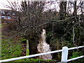
Newton Brook, Belmont, Hereford
A small tributary of the River Wye, into which it flows 550 metres behind the camera.
Image: © Jaggery
Taken: 7 Feb 2017
0.19 miles
2
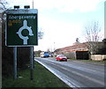
Abergavenny direction sign in Belmont, Hereford
Facing westbound traffic on the A465 Belmont Road on the approach to a roundabout.
Image: © Jaggery
Taken: 7 Feb 2017
0.21 miles
3
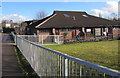
Belmont Community Centre, Hereford
On the south side of the A465. A nearby nameboard shows
BELMONT COMMUNITY CENTRE
SOUTH WYE COMMUNITY ASSOCIATION
REGISTERED CHARITY No. 700471.
Image: © Jaggery
Taken: 7 Feb 2017
0.21 miles
4
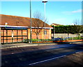
Belmont Road bus stop and shelter, Hereford
This side of the road for buses to the city centre.
Image: © Jaggery
Taken: 7 Feb 2017
0.21 miles
5
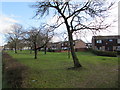
Early February 2017 view of deciduous trees on the south side of Belmont Road, Hereford
In early February, the duration of daylight at this latitude is about 2 hours more than on the shortest day in December, but today spring still seems a long way off, during a period of chilly weather with easterly winds from continental Europe. It will be many weeks before these trees are in leaf.
Image: © Jaggery
Taken: 7 Feb 2017
0.21 miles
6
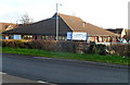
Belmont Community Centre and Library, Hereford
This is the Belmont Road (A465) side of the building, located opposite Tescos. http://www.geograph.org.uk/photo/3105858
The Belmont branch of the Herefordshire County Council library service occupies part of the building. The other part is occupied by the community centre. The centre's hall has a seating capacity of 90. There are three bookable rooms.
The car park and main entrances are from Eastholme Avenue on the far side of the building.
Image: © Jaggery
Taken: 13 Jan 2012
0.21 miles
7
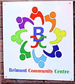
Multicoloured Belmont Community Centre name sign, Hereford
On the north side of this building, http://www.geograph.org.uk/photo/5278045 facing the A465.
Image: © Jaggery
Taken: 7 Feb 2017
0.22 miles
8
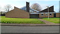
St Francis of Assisi church and community centre, Hereford
Viewed across Goodrich Grove. The Church of England church on the left and community centre on the right were built in the 1960s.
Image: © Jaggery
Taken: 13 Jan 2012
0.22 miles
9
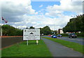
Welcome to Hereford
The sign on the A465 approaching the city from the south-west.
The flags on the left are in the grounds of the Three Counties Hotel.
Image: © Jonathan Billinger
Taken: 12 Aug 2008
0.24 miles
10
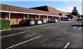
Tesco superstore and car park, Hereford
Viewed from the edge of Abbotsmead Road. This side of the superstore extends for 120 metres (nearly 400 feet).
Image: © Jaggery
Taken: 7 Feb 2017
0.24 miles