IMAGES TAKEN NEAR TO
Waterfield Road, HEREFORD, HR2 7EL
Introduction
This page details the photographs taken nearby to Waterfield Road, HR2 7EL by members of the Geograph project.
The Geograph project started in 2005 with the aim of publishing, organising and preserving representative images for every square kilometre of Great Britain, Ireland and the Isle of Man.

There are currently over 7.5m images from over14,400 individuals and you can help contribute to the project by visiting https://www.geograph.org.uk
Image Map
Images are licensed for reuse under creativecommons.org/licenses/by-sa/2.0
Notes
- Clicking on the map will re-center to the selected point.
- The higher the marker number, the further away the image location is from the centre of the postcode.
Image Listing (35 Images Found)
Images are licensed for reuse under creativecommons.org/licenses/by-sa/2.0
Image
Details
Distance
1
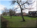
Early February 2017 view of deciduous trees on the south side of Belmont Road, Hereford
In early February, the duration of daylight at this latitude is about 2 hours more than on the shortest day in December, but today spring still seems a long way off, during a period of chilly weather with easterly winds from continental Europe. It will be many weeks before these trees are in leaf.
Image: © Jaggery
Taken: 7 Feb 2017
0.10 miles
2
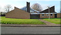
St Francis of Assisi church and community centre, Hereford
Viewed across Goodrich Grove. The Church of England church on the left and community centre on the right were built in the 1960s.
Image: © Jaggery
Taken: 13 Jan 2012
0.10 miles
3
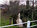
Newton Brook, Belmont, Hereford
A small tributary of the River Wye, into which it flows 550 metres behind the camera.
Image: © Jaggery
Taken: 7 Feb 2017
0.10 miles
4
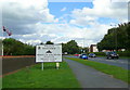
Welcome to Hereford
The sign on the A465 approaching the city from the south-west.
The flags on the left are in the grounds of the Three Counties Hotel.
Image: © Jonathan Billinger
Taken: 12 Aug 2008
0.12 miles
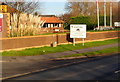
5
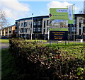
Radford Gardens name sign, Hereford
On the corner of Belmont Road and Goodrich Grove, viewed in early February 2017.
The Keepmoat sign states that Radford Gardens is a new development of 2- 3- and 4-bedroom homes.
The Sales Information Centre is open. A show home is now open for inspection.
Image: © Jaggery
Taken: 7 Feb 2017
0.12 miles
6
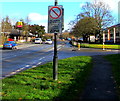
Zone sign on a Belmont Road lamppost, Hereford
Located near the corner of Goodrich Grove, the sign marks the start of a zone where vehicles are not allowed to park on footways, verges or centre reserves. Though the location of a sign here suggests that such parking is allowed elsewhere in the city, this seems very unlikely.
Image: © Jaggery
Taken: 7 Feb 2017
0.13 miles
7
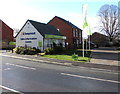
Keepmoat Sales Information Centre, Goodrich Grove, Hereford
Part of the Radford Gardens housing development on the south side of Belmont Road, viewed in February 2017.
Image: © Jaggery
Taken: 7 Feb 2017
0.13 miles
8
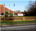
Three flagpoles on the north side of Belmont Road, Hereford
The flagpoles are in the grounds of the Three Counties Hotel.
On the right, a board advertises The Big Hereford Wedding Show
to be held in the hotel from 11am to 3pm on March 12th 2017.
Image: © Jaggery
Taken: 7 Feb 2017
0.13 miles
9
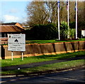
Welcome to Hereford, Historic City of The Marches
The city boundary sign facing the A465 Belmont Road shows that
Hereford is twinned with Dillenburg (Germany) and Vierzon (France).
Image: © Jaggery
Taken: 7 Feb 2017
0.13 miles
10
SW boundary of Hereford
Viewed across Belmont Road, opposite The Three Counties Hotel. http://www.geograph.org.uk/photo/3105871
The boundary sign describes Hereford as The Historic City of The Marches.
It shows that Hereford is twinned with Dillenburg (Germany) and Vierzon (France).
Image: © Jaggery
Taken: 13 Jan 2012
0.13 miles