IMAGES TAKEN NEAR TO
Brampton Road, HEREFORD, HR2 7DQ
Introduction
This page details the photographs taken nearby to Brampton Road, HR2 7DQ by members of the Geograph project.
The Geograph project started in 2005 with the aim of publishing, organising and preserving representative images for every square kilometre of Great Britain, Ireland and the Isle of Man.

There are currently over 7.5m images from over14,400 individuals and you can help contribute to the project by visiting https://www.geograph.org.uk
Image Map
Images are licensed for reuse under creativecommons.org/licenses/by-sa/2.0
Notes
- Clicking on the map will re-center to the selected point.
- The higher the marker number, the further away the image location is from the centre of the postcode.
Image Listing (6 Images Found)
Images are licensed for reuse under creativecommons.org/licenses/by-sa/2.0
Image
Details
Distance
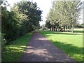
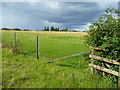
2
Grassland near Hereford
The trees mark the course of an old railway.
Image: © JThomas
Taken: 10 Aug 2021
0.06 miles
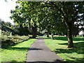
3
On the old railway track, now a cycle path, heading south
Image: © Rob Purvis
Taken: 26 Aug 2015
0.15 miles
4
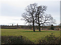
View west from Grafton Lane
Across the Hereford to Abergavenny railway line. This separates the suburbs of Hereford from the agricultural land to the south.
Image: © Pauline E
Taken: 16 Feb 2009
0.20 miles
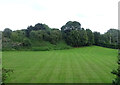
5
Grazing land north of Grafton Lane
Beyond the brow of the slope is the Hereford to Abergavenny railway line which separates this rural scene from the housing estates of South Hereford.
Image: © Jonathan Billinger
Taken: 12 Aug 2008
0.22 miles
6
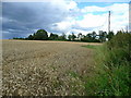
Wheat field at Grafton 1
Looking north-east; the housing estates of Hereford are only half a gridsquare to the north of here, but in between is the Hereford to Abergavenny railway line.
Image: © Jonathan Billinger
Taken: 12 Aug 2008
0.23 miles