IMAGES TAKEN NEAR TO
Brampton Road, HEREFORD, HR2 7DF
Introduction
This page details the photographs taken nearby to Brampton Road, HR2 7DF by members of the Geograph project.
The Geograph project started in 2005 with the aim of publishing, organising and preserving representative images for every square kilometre of Great Britain, Ireland and the Isle of Man.

There are currently over 7.5m images from over14,400 individuals and you can help contribute to the project by visiting https://www.geograph.org.uk
Image Map
Images are licensed for reuse under creativecommons.org/licenses/by-sa/2.0
Notes
- Clicking on the map will re-center to the selected point.
- The higher the marker number, the further away the image location is from the centre of the postcode.
Image Listing (3 Images Found)
Images are licensed for reuse under creativecommons.org/licenses/by-sa/2.0
Image
Details
Distance
1
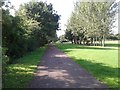
On the old railway track, now a cycle path, heading south
Image: © Rob Purvis
Taken: 26 Aug 2015
0.15 miles
2
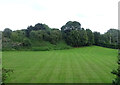
Grassland near Hereford
The trees mark the course of an old railway.
Image: © JThomas
Taken: 10 Aug 2021
0.24 miles
3
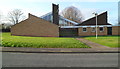
St Francis of Assisi church and community centre, Hereford
Viewed across Goodrich Grove. The Church of England church on the left and community centre on the right were built in the 1960s.
Image: © Jaggery
Taken: 13 Jan 2012
0.25 miles