
IMAGES TAKEN NEAR TO
Cagebrook Avenue, HEREFORD, HR2 7AS
Introduction
This page details the photographs taken nearby to Cagebrook Avenue, HR2 7AS by members of the Geograph project.
The Geograph project started in 2005 with the aim of publishing, organising and preserving representative images for every square kilometre of Great Britain, Ireland and the Isle of Man.

There are currently over 7.5m images from over14,400 individuals and you can help contribute to the project by visiting https://www.geograph.org.uk
Image Map
Images are licensed for reuse under creativecommons.org/licenses/by-sa/2.0
Notes
- Clicking on the map will re-center to the selected point.
- The higher the marker number, the further away the image location is from the centre of the postcode.
Image Listing (77 Images Found)
Images are licensed for reuse under creativecommons.org/licenses/by-sa/2.0
Image
Details
Distance
1
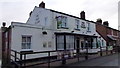
The Vaga Tavern, Hunderton, Hereford
A classic backstreet local situated in a quiet street of Hereford's south bank.
Image: © Jonathan Billinger
Taken: 20 Feb 2015
0.07 miles
2
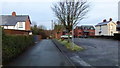
Vaga Street, Hunderton, Hereford
The car park for the Vaga Tavern to the left; houses on Villa Street at the T junction front the River Wye.
Image: © Jonathan Billinger
Taken: 20 Feb 2015
0.08 miles
3
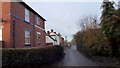
Villa Street, Hunderton, Hereford
Housing from the early 20th century on a road parallel to the River Wye, unseen to the right of shot.
Image: © Jonathan Billinger
Taken: 20 Feb 2015
0.08 miles
4
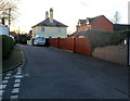
Villa Street, Hereford
Viewed from the corner of Wallis Avenue. Villa Street is on the south bank of the River Wye.
Image: © Jaggery
Taken: 13 Jan 2012
0.11 miles
5
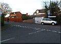
Villa Street left, Luard Walk right, Hereford
This T-junction is on the south bank of the River Wye, viewed from Wallis Avenue.
Image: © Jaggery
Taken: 13 Jan 2012
0.13 miles
6
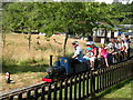
Broomy Hill Railway
The 5" gauge trains operated by the Hereford Society of Model Engineers feature all round air conditioning, very popular in the current heatwave.
Image: © Keith Edkins
Taken: 14 Jul 2013
0.14 miles
7

Broomy Hill Railway - Signal and point levers
Black levers work points, red levers work signals; three of the latter operate the signals seen in Image by air pressure. Because of the risk of flooding from the nearby river, the whole set of levers can be lifted up out of the way.
Image: © John Webb
Taken: 28 Jun 2009
0.15 miles
8

Broomy Hill Railway - signals
Signals on the Broomy Hill Miniature Railway operated by the Hereford Society of Model Engineers (see http://www.hsme.co.uk/ ).
Based on the Great Western Railway's lower quadrant signals, these are worked by compressed air put into the cylinder that can be seen on the side of each post. This system was chosen in preference to electrical operation since the area is prone to flooding from the adjacent River Wye. See Image for a general view of the station.
Image: © John Webb
Taken: 28 Jun 2009
0.15 miles
9
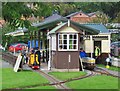
Broomy Hill station, Hereford
This station opens on alternate Sundays in season, and provides a continuous service of trains to the delight of the many visitors it attracts.
Image: © Flying Stag
Taken: 26 Sep 2010
0.16 miles
10
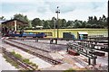
Broomy Hill Railway
View of the rear of the main station on the miniature railway operated by the Hereford Society of Model Engineers http://www.hsme.co.uk/, who are based next to the Waterworks Museum. This is a mixed gauge track (5/7.25 inch). Immediately in front of the camera are the 'steaming bays' where on the right the locos can be unloaded from the back of a vehicle and eventually bought to ground level by the ramp system crossing the middle of the picture.
See the website for details of public steaming days. (Although there is a warning that these may have to be cancelled at short notice due to flooding from the River Wye - this is out of sight beyond the distant hedge!) See also Image
Image: © John Webb
Taken: 28 Jun 2009
0.16 miles