IMAGES TAKEN NEAR TO
Hunderton Road, HEREFORD, HR2 7AE
Introduction
This page details the photographs taken nearby to Hunderton Road, HR2 7AE by members of the Geograph project.
The Geograph project started in 2005 with the aim of publishing, organising and preserving representative images for every square kilometre of Great Britain, Ireland and the Isle of Man.

There are currently over 7.5m images from over14,400 individuals and you can help contribute to the project by visiting https://www.geograph.org.uk
Image Map
Images are licensed for reuse under creativecommons.org/licenses/by-sa/2.0
Notes
- Clicking on the map will re-center to the selected point.
- The higher the marker number, the further away the image location is from the centre of the postcode.
Image Listing (76 Images Found)
Images are licensed for reuse under creativecommons.org/licenses/by-sa/2.0
Image
Details
Distance
1
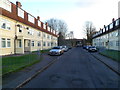
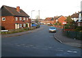
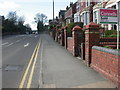
Hunderton Road flats, Hereford
A view SE along Hunderton Road towards a former railway bridge. http://www.geograph.org.uk/photo/3492466
Image: © Jaggery
Taken: 13 Jan 2012
0.04 miles
2
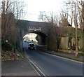
Former Hunderton Road railway bridge, Hereford
Formerly carrying a railway over Hunderton Road, the 10' 9" headroom stone bridge now carries a footpath.
Image: © Jaggery
Taken: 13 Jan 2012
0.04 miles
3
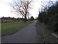
National Cycle Network route 46 towards Hereford city centre
A combined cycleway and footpath on a former railway route, viewed from the northern end of this bridge. http://www.geograph.org.uk/photo/5280328
Image: © Jaggery
Taken: 7 Feb 2017
0.05 miles
4
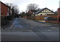
Hunderton Road, Hereford
From Belmont Road along Hunderton Road towards a former railway bridge.
Image: © Jaggery
Taken: 7 Feb 2017
0.05 miles
5
Hunderton Avenue, Hereford
Viewed across Hunderton Road. According to one online source, both these street names are unique in the UK.
Image: © Jaggery
Taken: 13 Jan 2012
0.05 miles
6
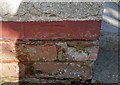
Ordnance Survey Cut Mark
This almost lost OS cut mark can be found on No17 Charles Witts Avenue. It marks a point 55.102m above mean sea level.
Image: © Adrian Dust
Taken: 10 Mar 2019
0.08 miles
7
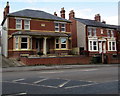
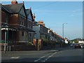
Edwardian semi-detached houses, Belmont Road, Hereford
The inscription on the tablet between the first floor windows is The Hawthorns 1904.
Image: © Jaggery
Taken: 7 Feb 2017
0.11 miles
8
Belmont Road semis, Hereford
Semi-detached houses opposite the Walnut Tree Avenue junction.
Image: © Jaggery
Taken: 7 Feb 2017
0.11 miles
9
Hereford, disused postbox
GVR postbox built into a gate post on Belmont Road.
Image: © Mike Faherty
Taken: 8 Apr 2010
0.12 miles
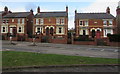
10
Belmont Road, Hereford, from the junction with Hunderton Road
A road lined on one side with Victorian/early 20th century semi-detached houses
Image: © David Smith
Taken: 23 Jul 2013
0.12 miles