1
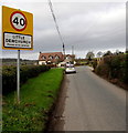
Unsuitable road for heavy goods vehicles, Little Dewchurch
Opposite the Little Dewchurch boundary sign, http://www.geograph.org.uk/photo/4307369 a minor road heads towards Carey, 3km ahead.
Image: © Jaggery
Taken: 11 Jan 2015
0.02 miles
2
Please drive carefully in Little Dewchurch
The National Speed Limit on the minor road from Hoarwithy reduces
to 40mph at the SE edge of Little Dewchurch, a village in Herefordshire.
Image: © Jaggery
Taken: 11 Jan 2015
0.02 miles
3
On the move
A large piece of harvesting machinery between Hoarwithy and Little Dewchurch.
Image: © Jonathan Billinger
Taken: 25 Sep 2010
0.03 miles
4
Little Dewchurch boundary sign
The minor road from Hoarwithy reaches Little Dewchurch, a village in Herefordshire.
Image: © Jaggery
Taken: 11 Jan 2015
0.04 miles
5
Hill View and bus stop at the edge of Little Dewchurch
Image: © Rob Purvis
Taken: 26 Aug 2015
0.05 miles
6
Lane to Little Dewchurch
Looking north-west to village houses and Rough Hill Wood in the distance.
Image: © Trevor Rickard
Taken: 31 Jan 2011
0.14 miles
7
Farmland on the slopes, Little Dewchurch
The land rolls down towards Hoarwithy and the Wye Valley.
Image: © Pauline E
Taken: 5 Dec 2007
0.22 miles
8
The Herefordshire Trail south of Little Dewchurch
Looking north towards Little Dewchurch on the left and Hill View on the right. Mainly arable land with potentially muddy conditions in winter. Here there is a rough walk along the hedgerow to rejoin the path route, which cuts across the corner of this field.
The Herefordshire Trail is an excellent 154-mile circular route around the whole county - http://www.herefordshiretrail.com/
Image: © Trevor Rickard
Taken: 31 Jan 2011
0.22 miles
9
Eco-friendly speed warning sign, Little Dewchurch
This speed warning sign is on the lane approaching Little Dewchurch.
Image: © Philip Halling
Taken: 8 Apr 2006
0.24 miles
10
Little Dewchurch
The Plough, white building on the right; modern housing in the distance, to the left.
Image: © Mike Faherty
Taken: 8 Apr 2010
0.24 miles


