IMAGES TAKEN NEAR TO
Little Dewchurch, HEREFORD, HR2 6PP
Introduction
This page details the photographs taken nearby to HR2 6PP by members of the Geograph project.
The Geograph project started in 2005 with the aim of publishing, organising and preserving representative images for every square kilometre of Great Britain, Ireland and the Isle of Man.

There are currently over 7.5m images from over14,400 individuals and you can help contribute to the project by visiting https://www.geograph.org.uk
Image Map
Images are licensed for reuse under creativecommons.org/licenses/by-sa/2.0
Notes
- Clicking on the map will re-center to the selected point.
- The higher the marker number, the further away the image location is from the centre of the postcode.
Image Listing (5 Images Found)
Images are licensed for reuse under creativecommons.org/licenses/by-sa/2.0
Image
Details
Distance
1
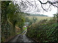
Narrow lane to Lower Knapp Green
The metalled road terminates at Knapp Green Farm, a little further along.
Image: © Jonathan Billinger
Taken: 29 Mar 2010
0.02 miles
2
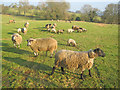
Sheep at Lower Knapp Green
Looking east from the lane. A significant time as these are the first lambs I've seen outdoors in 2011 - despite the freezing day, a true sign of spring approaching.
Image: © Trevor Rickard
Taken: 31 Jan 2011
0.04 miles
3
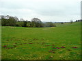
Moley ground
Looking east along the line of a footpath from Lower Knapp Green towards Witherstone.
Image: © Jonathan Billinger
Taken: 29 Mar 2010
0.10 miles
4
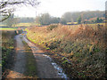
Track at Knapp Green
This track leads east from Knapp Green Farm, then sharp left at the bottom of this slope for Lower Knapp Green. Shown on the map as a metalled road, which seems a little ambitious. Ballis Wood on the right.
Image: © Trevor Rickard
Taken: 31 Jan 2011
0.13 miles
5
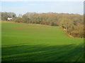
Arable land and woodland at Ballis Wood
View north from the public footpath to an isolated house on the edge of the wood.
Image: © Trevor Rickard
Taken: 31 Jan 2011
0.20 miles