IMAGES TAKEN NEAR TO
Manor Road, HEREFORD, HR2 6HN
Introduction
This page details the photographs taken nearby to Manor Road, HR2 6HN by members of the Geograph project.
The Geograph project started in 2005 with the aim of publishing, organising and preserving representative images for every square kilometre of Great Britain, Ireland and the Isle of Man.

There are currently over 7.5m images from over14,400 individuals and you can help contribute to the project by visiting https://www.geograph.org.uk
Image Map
Images are licensed for reuse under creativecommons.org/licenses/by-sa/2.0
Notes
- Clicking on the map will re-center to the selected point.
- The higher the marker number, the further away the image location is from the centre of the postcode.
Image Listing (7 Images Found)
Images are licensed for reuse under creativecommons.org/licenses/by-sa/2.0
Image
Details
Distance
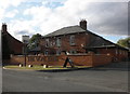
2
Fish and Chip Shop and Chinese takeaway in Lower Bullingham, Hereford
The Manor chippy and takeaway serves the local community here.
Image: © Jeremy Bolwell
Taken: 16 Jun 2019
0.22 miles
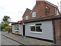
3
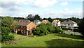
Old farmhouse in Lower Bullingham, Hereford
A tall and imposing building, now surrounded by housing estates.
Image: © Jeremy Bolwell
Taken: 16 Jun 2019
0.23 miles
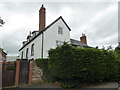
4
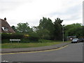
Gateway on Hinton Road
A gateway in the wall of Putson Manor, in what is nowadays a residential road on the outskirts of Hereford, but would have once been an isolated manor house on the banks of the River Wye.
Image: © John Winder
Taken: 1 Dec 2019
0.23 miles
7
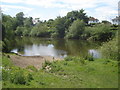
River Wye at Putson
View southwards across the river to houses on Hinton Road.
Image: © Trevor Rickard
Taken: 14 Jun 2008
0.24 miles