IMAGES TAKEN NEAR TO
St. Martins Court, HEREFORD, HR2 6GN
Introduction
This page details the photographs taken nearby to St. Martins Court, HR2 6GN by members of the Geograph project.
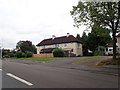
The Geograph project started in 2005 with the aim of publishing, organising and preserving representative images for every square kilometre of Great Britain, Ireland and the Isle of Man.

There are currently over 7.5m images from over14,400 individuals and you can help contribute to the project by visiting https://www.geograph.org.uk
Image Map
Images are licensed for reuse under creativecommons.org/licenses/by-sa/2.0
Notes
- Clicking on the map will re-center to the selected point.
- The higher the marker number, the further away the image location is from the centre of the postcode.
Image Listing (84 Images Found)
Images are licensed for reuse under creativecommons.org/licenses/by-sa/2.0
Image
Details
Distance
1
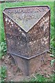
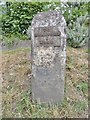
Old Milepost by the B4399, Holme Lacy Road, Hereford
Cast iron post by the B4399, in parish of HEREFORD (District), Holme Lacy Road, by The Broadleys P.H., St Martin's, West of Putson, on bank at junction with the A466, on South side of road. Hereford iron T-post, erected by the Hereford turnpike trust in the 19th century.
Inscription reads:-
: TO / HEREFORD / 1 / MILE : : St. MARTIN'S / PARISH : : TO / HOMLACY / 5 / MILES :
Maker:-
: C HODGES / & / SON / HEREFORD / FOUNDRY 1849 :
Herefordshire SMR listed. SMR Number: 56580 https://www.heritagegateway.org.uk/Gateway/Results_Single.aspx?uid=MHE28337&resourceID=101
Milestone Society National ID: HF_HFHL01.
Image: © B Barrow
Taken: 10 Apr 2010
0.02 miles
2
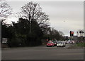
Western end of Holme Lacy Road, Hereford
Viewed across the A49 Ross Road.
Image: © Jaggery
Taken: 7 Feb 2017
0.03 miles
3
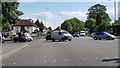
Junction of Holme Lacy Road and the A49 Ross Road, Hereford
Holme Lacy Road is on the left. The Broadleys pub http://www.geograph.org.uk/photo/5275721 is in the background.
Image: © Jaggery
Taken: 7 Feb 2017
0.03 miles
4
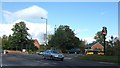
Ross Road/Holme Lace Road junction, Hereford
Major junction on the route to the south of the city centre.
Image: © Jonathan Billinger
Taken: 19 Mar 2016
0.03 miles
5
Junction of A49 and B4399 (Holme Lacy Road)
Image: © David Smith
Taken: 19 Oct 2010
0.03 miles
6
Old Milestone by the A49, Ross Road, Hereford
Metal plate attached to stone post by the A49, in parish of Hereford (Hereford District), Ross Road, junction with Holme Lacy Road outside The Broadleys PH, on bank by car park entrance, on East side of road. Hereford iron plate, erected by the Hereford Turnpike Trust in the 19th century.
Inscription reads:-
TO
HEREFORD
1
MILE
Carved benchmark and rivet on top.
Milestone Society National ID: HF_HFRS01.
Image: © Milestone Society
Taken: 15 Jul 2018
0.03 miles
7
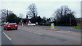
Junction of Ross Road and Holme Lacy Road
Image: © Helen Steed
Taken: 7 Aug 2019
0.03 miles
8
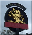
Sign for the Broadleys public house, Hereford
See Image] for context.
Image: © JThomas
Taken: 4 Apr 2019
0.04 miles
9
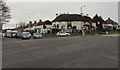
The Broadleys
Plans were afoot to demolish this pub and build a Co-op, but the plans were turned down.
Image: © Eirian Evans
Taken: 30 Aug 2019
0.04 miles
10
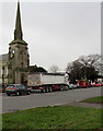
Queuing traffic on the A49 Ross Road, Hereford
Traffic is stopped at red lights at the Holme Lacy Road junction.
The spire of St Martin's Church http://www.geograph.org.uk/photo/5275751 is in the background.
Image: © Jaggery
Taken: 7 Feb 2017
0.04 miles