IMAGES TAKEN NEAR TO
Harris Court, HEREFORD, HR2 6FD
Introduction
This page details the photographs taken nearby to Harris Court, HR2 6FD by members of the Geograph project.
The Geograph project started in 2005 with the aim of publishing, organising and preserving representative images for every square kilometre of Great Britain, Ireland and the Isle of Man.

There are currently over 7.5m images from over14,400 individuals and you can help contribute to the project by visiting https://www.geograph.org.uk
Image Map
Images are licensed for reuse under creativecommons.org/licenses/by-sa/2.0
Notes
- Clicking on the map will re-center to the selected point.
- The higher the marker number, the further away the image location is from the centre of the postcode.
Image Listing (13 Images Found)
Images are licensed for reuse under creativecommons.org/licenses/by-sa/2.0
Image
Details
Distance
2
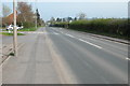
Holme Lacy Road, Hereford
In the distance the railway bridge carrying the Hereford to Abergavenny line can be seen.
Image: © Philip Halling
Taken: 22 Apr 2006
0.08 miles
3

Canoe & Stump
A lot of canoes were out on the River Wye today. Houses in Lower Bullingham in the background.
Image: © Des Blenkinsopp
Taken: 10 Aug 2013
0.12 miles
4
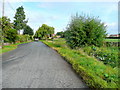
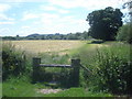
Watery Lane, Lower Bullingham
This dead-end lane crosses the south-west corner of the gridsquare in this view looking towards Hereford.
Image: © Jonathan Billinger
Taken: 25 Aug 2009
0.13 miles
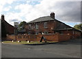
6
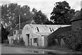
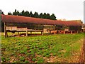
Old buildings on Holme Lacy Road
Next door to the Wye Inn (where I and my colleagues go for a post - work beer most Fridays) is this collection of derelict buildings. I've often meant to photograph them but always been a bit too eager to get to the pub! Cycling past them last Friday on a rare day off work gave me the opportunity to snap this.
Image: © John Winder
Taken: 16 Sep 2016
0.13 miles
7
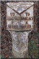
Old Milepost by the B4399, Holme Lacy Road, Lower Bullingham
Cast iron post by the B4399, in parish of LOWER BULLINGHAM (District), West of Industrial estate; 200m from railway bridge, on verge, near Speed Camera sign, on West side of road. Hereford iron T-post, erected by the Hereford turnpike trust in the 19th century.
Inscription reads:-
: TO / HEREFORD / 2 / MILES : : BULLINGHAM / PARISH : : TO / HOMLACY / 4 / MILES :
Herefordshire SMR listed.
SMR Number: 56581 https://www.heritagegateway.org.uk/Gateway/Results_Single.aspx?uid=MHE28338&resourceID=101
Milestone Society National ID: HF_HFHL02.
Image: © T Boyce
Taken: 2 Nov 2003
0.16 miles
9
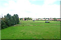
Riverside path on Bartonsham Farm - 1
View south-east to Rotherwas Park Wood and Rough Hill on the horizon. The Hereford sewage works are in the trees on the other side of the field.
Image: © Trevor Rickard
Taken: 14 Jun 2008
0.20 miles
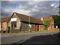
10
The Wye Inn, Holme Lacy Road, Putson
Image: © Roger Cornfoot
Taken: 2 Sep 2011
0.20 miles