IMAGES TAKEN NEAR TO
Newton St. Margarets, HEREFORD, HR2 0QY
Introduction
This page details the photographs taken nearby to HR2 0QY by members of the Geograph project.
The Geograph project started in 2005 with the aim of publishing, organising and preserving representative images for every square kilometre of Great Britain, Ireland and the Isle of Man.

There are currently over 7.5m images from over14,400 individuals and you can help contribute to the project by visiting https://www.geograph.org.uk
Image Map
Images are licensed for reuse under creativecommons.org/licenses/by-sa/2.0
Notes
- Clicking on the map will re-center to the selected point.
- The higher the marker number, the further away the image location is from the centre of the postcode.
Image Listing (5 Images Found)
Images are licensed for reuse under creativecommons.org/licenses/by-sa/2.0
Image
Details
Distance
1
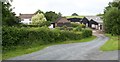
Upper Gilvach
The notice for the farm and B&b calls it Upper Gilvach. The OS map shows it as Upper Gilfach
Image: © Bob Embleton
Taken: 31 May 2007
0.11 miles
2
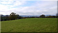
Pasture land at Gilfach
Looking west to the Hatterall Ridge of the Black Mountains.
Image: © Jonathan Billinger
Taken: 22 Nov 2013
0.13 miles
3
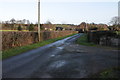
Road approaching Gilfach
Road approaching Gilfach, with the farm Upper Gilfach on the left in the middle distance.
Image: © Philip Halling
Taken: 3 Dec 2011
0.14 miles
4
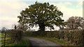
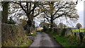
Lane and oak
Many lanes and oaks in this corner of Herefordshire.
Image: © Jonathan Billinger
Taken: 22 Nov 2013
0.19 miles
5
Road past Shobdon Barn
Leading east to St. Margarets.
Image: © Jonathan Billinger
Taken: 22 Nov 2013
0.22 miles