IMAGES TAKEN NEAR TO
Newton St. Margarets, HEREFORD, HR2 0QS
Introduction
This page details the photographs taken nearby to HR2 0QS by members of the Geograph project.
The Geograph project started in 2005 with the aim of publishing, organising and preserving representative images for every square kilometre of Great Britain, Ireland and the Isle of Man.

There are currently over 7.5m images from over14,400 individuals and you can help contribute to the project by visiting https://www.geograph.org.uk
Image Map
Images are licensed for reuse under creativecommons.org/licenses/by-sa/2.0
Notes
- Clicking on the map will re-center to the selected point.
- The higher the marker number, the further away the image location is from the centre of the postcode.
Image Listing (3 Images Found)
Images are licensed for reuse under creativecommons.org/licenses/by-sa/2.0
Image
Details
Distance
1
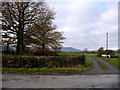
Track to Wainherbert
The distinctive profile of Hay Bluff can be seen in the distance.
Image: © Jonathan Billinger
Taken: 22 Nov 2013
0.10 miles
2
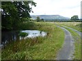
Driveway to Wainherbert Farm
The eastern ridge of the Black Mountains dominates the skyline.
Image: © Oliver Dixon
Taken: 3 Sep 2020
0.11 miles
3
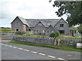
Old school house near Cae Garw?
What looks very like an old school now converted to private accommodation.
Image: © Oliver Dixon
Taken: 3 Sep 2020
0.12 miles