IMAGES TAKEN NEAR TO
Michaelchurch Escley, HEREFORD, HR2 0PT
Introduction
This page details the photographs taken nearby to HR2 0PT by members of the Geograph project.
The Geograph project started in 2005 with the aim of publishing, organising and preserving representative images for every square kilometre of Great Britain, Ireland and the Isle of Man.

There are currently over 7.5m images from over14,400 individuals and you can help contribute to the project by visiting https://www.geograph.org.uk
Image Map
Images are licensed for reuse under creativecommons.org/licenses/by-sa/2.0
Notes
- Clicking on the map will re-center to the selected point.
- The higher the marker number, the further away the image location is from the centre of the postcode.
Image Listing (3 Images Found)
Images are licensed for reuse under creativecommons.org/licenses/by-sa/2.0
Image
Details
Distance
1
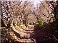
The main road that was
Few people live hereabouts and the width of this track surprised us. Wider than necessary for pack animals yet this must be a very old track, sunk between raised banks. Who needed this wide track and who did the hard work to make it so wide? Were the banks topped with stock proof hedges or were they built up only to mark the way through woods and keep traffic on the chosen route?
Image: © Graham Cole
Taken: 1 Mar 2009
0.08 miles
2
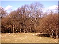
Woodland pasture
The old farming practice of keeping woodland and letting animals use it for shelter and feeding is rarely found now in Herefordshire. Woodland is usually small in area, more dense and with livestock excluded.
Despite having warm woolly coats the local sheep huddle in sheltered places when a cold wind blows, giving an extra reason for keeping hedges and trees on the land.
Image: © Graham Cole
Taken: 1 Mar 2009
0.15 miles
3
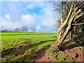
Windswept Hawthorn
Or maybe just leaned on by various animals throughout its existence!
Image: © Jonathan Billinger
Taken: 28 Dec 2011
0.24 miles