IMAGES TAKEN NEAR TO
Blunden Meadows, HR2 0PQ
Introduction
This page details the photographs taken nearby to Blunden Meadows, HR2 0PQ by members of the Geograph project.
The Geograph project started in 2005 with the aim of publishing, organising and preserving representative images for every square kilometre of Great Britain, Ireland and the Isle of Man.

There are currently over 7.5m images from over14,400 individuals and you can help contribute to the project by visiting https://www.geograph.org.uk
Image Map
Images are licensed for reuse under creativecommons.org/licenses/by-sa/2.0
Notes
- Clicking on the map will re-center to the selected point.
- The higher the marker number, the further away the image location is from the centre of the postcode.
Image Listing (20 Images Found)
Images are licensed for reuse under creativecommons.org/licenses/by-sa/2.0
Image
Details
Distance
1
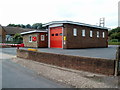
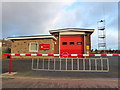
Ewyas Harold fire station
Located on Elm Green Road, near the SE edge of the village. The fire station is part of Hereford & Worcester Fire and Rescue Service. The adjacent sewage pumping station http://www.geograph.org.uk/photo/2640395 however is owned by Welsh Water. Ewyas Harold is in SW Herefordshire, England, about 2 miles (roughly 3km) from the Welsh border.
A change since this view http://www.geograph.org.uk/photo/460768 taken four years earlier is that the station name sign has been moved from the roadside to a wall of the station.
Image: © Jaggery
Taken: 9 Sep 2011
0.02 miles
2
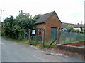
Elmdale Sewage Pumping Station, Ewyas Harold
Located next door to the fire station. http://www.geograph.org.uk/photo/2640392
Although Ewyas Harold is about 2 miles on the English side of the border, this facility is owned by Welsh Water. http://www.geograph.org.uk/photo/2640401
Image: © Jaggery
Taken: 9 Sep 2011
0.02 miles
3
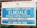
Ewyas Harold: Welsh Water facility in England
This is the name sign of a sewage pumping station http://www.geograph.org.uk/photo/2640395 in Ewyas Harold, about 2 miles on the English side of the Welsh border.
Image: © Jaggery
Taken: 9 Sep 2011
0.02 miles
4
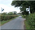
SE edge of Ewyas Harold
The 30mph speed limit in Ewyas Harold changes to the National Speed Limit at the SE edge of the village, a few metres east of the fire station. http://www.geograph.org.uk/photo/2640392
Image: © Jaggery
Taken: 9 Sep 2011
0.04 miles
5
Ewyas Harold Fire Station
Covering the southern Golden Valley country between Hereford and Abergavenny.
Image: © Jonathan Billinger
Taken: 21 Jan 2012
0.05 miles
6
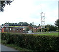
Drill tower, Ewyas Harold fire station
Located in the NE corner of the fire station. http://www.geograph.org.uk/photo/2640392
Image: © Jaggery
Taken: 9 Sep 2011
0.06 miles
7
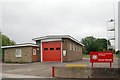
Ewyas Harold Fire Station
Ewyas Harold Fire Station, Elmdale, Ewyas Harold is part of Hereford & Worcester Fire Brigade
Image: © Kevin Hale
Taken: 3 Jun 2007
0.06 miles
8
Elmdale, Ewyas Harold
The street name sign on the left shows Elmdale leading to Oakbrook Close.
Image: © Jaggery
Taken: 9 Sep 2011
0.10 miles
9
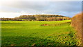
Callow Hill Wood
Lit by a rare shaft of January sunshine in this view across the Dore valley.
Image: © Jonathan Billinger
Taken: 21 Jan 2012
0.10 miles
10
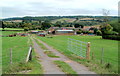
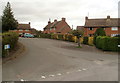
Farmland at the edge of Ewyas Harold
Farmland and farm buildings adjacent to the residential streets Gilberts Wood and Oakbrook Close. Viewed from the B4347.
Image: © Jaggery
Taken: 9 Sep 2011
0.14 miles