IMAGES TAKEN NEAR TO
Walterstone, HEREFORD, HR2 0PF
Introduction
This page details the photographs taken nearby to HR2 0PF by members of the Geograph project.
The Geograph project started in 2005 with the aim of publishing, organising and preserving representative images for every square kilometre of Great Britain, Ireland and the Isle of Man.

There are currently over 7.5m images from over14,400 individuals and you can help contribute to the project by visiting https://www.geograph.org.uk
Image Map
Images are licensed for reuse under creativecommons.org/licenses/by-sa/2.0
Notes
- Clicking on the map will re-center to the selected point.
- The higher the marker number, the further away the image location is from the centre of the postcode.
Image Listing (4 Images Found)
Images are licensed for reuse under creativecommons.org/licenses/by-sa/2.0
Image
Details
Distance
1
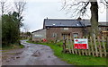
Upper Brooks Farm
A property is currently for sale here.
This is very isolated!
Image: © Jonathan Billinger
Taken: 21 Jan 2012
0.02 miles
2
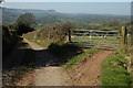
Track to Pen-y-lan
I've been here before Image] but didn't realise until uploading this picture. View to the Black Mountains and Black Hill from Mynydd Merddin.
Image: © Philip Halling
Taken: 17 Apr 2010
0.13 miles
3
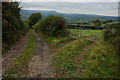
Track to Pen-y-lan
The Black Hill can be seen in the distance along with the Olchon Valley to the left.
Image: © Philip Halling
Taken: 30 Sep 2007
0.15 miles
4
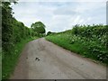
Church Road, heading north to Upper Brooks Farm
A no-through road climbing the south-east flank of Mynydd Merddin.
Image: © Christine Johnstone
Taken: 31 May 2017
0.23 miles