IMAGES TAKEN NEAR TO
Ewyas Harold, HEREFORD, HR2 0JJ
Introduction
This page details the photographs taken nearby to HR2 0JJ by members of the Geograph project.
The Geograph project started in 2005 with the aim of publishing, organising and preserving representative images for every square kilometre of Great Britain, Ireland and the Isle of Man.

There are currently over 7.5m images from over14,400 individuals and you can help contribute to the project by visiting https://www.geograph.org.uk
Image Map
Images are licensed for reuse under creativecommons.org/licenses/by-sa/2.0
Notes
- Clicking on the map will re-center to the selected point.
- The higher the marker number, the further away the image location is from the centre of the postcode.
Image Listing (18 Images Found)
Images are licensed for reuse under creativecommons.org/licenses/by-sa/2.0
Image
Details
Distance
1
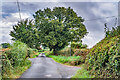
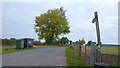
Tremorithic Road
Looking along Tremorithic Road, a lone which follows the ridge between the valley of the Dulas Brook and the Golden Valley. The drive to the left leads to Holling Grange Farm and that on the right to Upper Cefn.
Image: © Ian Capper
Taken: 9 Sep 2021
0.10 miles
2
Oaks by Tremorithic Road
Still green as at 17th October 2015.
Image: © Jonathan Billinger
Taken: 17 Oct 2015
0.11 miles
3
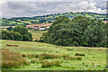
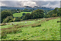
Near Upper Cefn
Field near Upper Cefn with Cwm Dulas Farm in the middle distance.
Image: © Ian Capper
Taken: 9 Sep 2021
0.11 miles
4
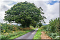
Tremorithic Road
Looking along Tremorithic Road, a lone which follows the ridge between the valley of the Dulas Brook and the Golden Valley.
Image: © Ian Capper
Taken: 9 Sep 2021
0.11 miles
5
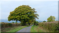
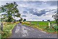
Farm track and public footpath
To Holling Grange Farm pictured from Tremorithic Road.
Image: © Jonathan Billinger
Taken: 17 Oct 2015
0.11 miles
6
Drive to Holling Grange Farm
Drive to Holling Grange Farm off Tremorithic Road.
Image: © Ian Capper
Taken: 9 Sep 2021
0.11 miles
7
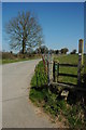
Driveway and stile
A stile to a footpath and the driveway to Holling Grange Farm.
Image: © Philip Halling
Taken: 17 Apr 2010
0.12 miles
8
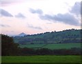
The Skirrid (Ysgyryd Fawr) from near Abbey Dore
The view from the minor road west north-west of Abbey Dore; fading light.
Image: © Hugh Chevallier
Taken: 17 Oct 2006
0.13 miles
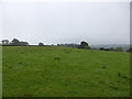
9
Near Upper Cefn
Field near Upper Cefn with the Black Mountains in the distance.
Image: © Ian Capper
Taken: 9 Sep 2021
0.14 miles
10
Looking across fields from Upper Cefn to Middle Cefn
Looking along the line of a footpath across undulating pastures between the two old farms.
Image: © Jeremy Bolwell
Taken: 18 Oct 2013
0.14 miles