IMAGES TAKEN NEAR TO
Walterstone, HEREFORD, HR2 0DZ
Introduction
This page details the photographs taken nearby to HR2 0DZ by members of the Geograph project.
The Geograph project started in 2005 with the aim of publishing, organising and preserving representative images for every square kilometre of Great Britain, Ireland and the Isle of Man.

There are currently over 7.5m images from over14,400 individuals and you can help contribute to the project by visiting https://www.geograph.org.uk
Image Map
Images are licensed for reuse under creativecommons.org/licenses/by-sa/2.0
Notes
- Clicking on the map will re-center to the selected point.
- The higher the marker number, the further away the image location is from the centre of the postcode.
Image Listing (9 Images Found)
Images are licensed for reuse under creativecommons.org/licenses/by-sa/2.0
Image
Details
Distance
1
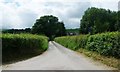
Church Road at the T junction
A no-through-road heading west to Mynydd Merddin.
Image: © Christine Johnstone
Taken: 31 May 2017
0.06 miles
2
Bracken-filled field margin, east of Bryngwyn
Looking south from the footpath signpost.
Image: © Christine Johnstone
Taken: 31 May 2017
0.09 miles
3
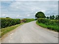
Road heading east towards Rowlestone
At a T junction, east of Bryngwyn.
Image: © Christine Johnstone
Taken: 31 May 2017
0.09 miles
4
Public footpath to Pen yr Heol Farm
Signposted at the T junction, but inaccessible and apparently little-used.
Image: © Christine Johnstone
Taken: 31 May 2017
0.10 miles
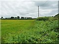
5
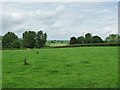
Sheep pasture, east of Greidol
On the north side of the road to Rowlestone.
Image: © Christine Johnstone
Taken: 31 May 2017
0.11 miles
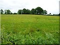
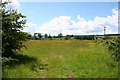
6
Farmland below Mynydd Ferddin
Farmland in this part of Herefordshire is predominantly grassing land.
Image: © Philip Halling
Taken: 17 Mar 2012
0.13 miles
7
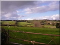
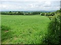
Interesting farmland
What I think is interesting in this picture is that the land is about 200 metres above sea level. The land may have been ploughed many years ago for growing cereals but now it's laid to pasture. Except, in the far left you can see a grass-track for motorcycles, complete with jumps. So it's not entirely sheep and cattle pasture. Incidentally, this is a wonderfully quiet corner of Herefordshire. If you come here be sure to have a detailed map and a good map reader because navigating by your sense of direction will not get you anywhere you want!
Image: © Graham Cole
Taken: 26 Oct 2008
0.21 miles
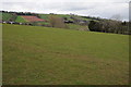
8
Buttercup Meadow
Taken from the start of Perthi-bâch Lane
Image: © Bob Embleton
Taken: 29 May 2007
0.22 miles
9
Sheep field on the north side of Church Road
On the eastern flank of Mynydd Merddin, just above Bryngwyn and Greidol.
Image: © Christine Johnstone
Taken: 31 May 2017
0.24 miles