IMAGES TAKEN NEAR TO
Garway Hill, HEREFORD, HR2 0DE
Introduction
This page details the photographs taken nearby to HR2 0DE by members of the Geograph project.
The Geograph project started in 2005 with the aim of publishing, organising and preserving representative images for every square kilometre of Great Britain, Ireland and the Isle of Man.

There are currently over 7.5m images from over14,400 individuals and you can help contribute to the project by visiting https://www.geograph.org.uk
Image Map
Images are licensed for reuse under creativecommons.org/licenses/by-sa/2.0
Notes
- Clicking on the map will re-center to the selected point.
- The higher the marker number, the further away the image location is from the centre of the postcode.
Image Listing (10 Images Found)
Images are licensed for reuse under creativecommons.org/licenses/by-sa/2.0
Image
Details
Distance
1
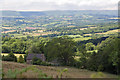
View towards the Black Mountains
With Old Kitchen Farm in the foreground.
Image: © Stuart Wilding
Taken: 6 Jul 2014
0.03 miles
2
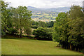
Farmland near Garway Hill
View towards the Sugar Loaf (Pen y Fal), the first hill on the left.
Image: © Stuart Wilding
Taken: 6 Jul 2014
0.04 miles
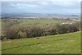
3
View towards the Black Mountains
View over Herefordshire countryside to the Black Mountains.
Image: © Stuart Wilding
Taken: 6 Jul 2014
0.20 miles

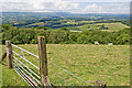
5
View to Grey Valley
View to Grey Valley in Herefordshire beyond Allensmore from a track on Garway Hill.
Image: © Philip Halling
Taken: 30 Jan 2023
0.22 miles
6
View to the Black Mountains
View to the Black Mountains from a track on Garway Hill. The track provides access to Old Kitchen Farm.
Image: © Philip Halling
Taken: 30 Jan 2023
0.22 miles
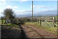
8

The Herefordshire Trail
This lane forms part of the Herefordshire trail, a 154 mile long distance footpath forming a circular walk in Herefordshire. That said, I didn't see a marker for it all day.
Image: © Stuart Wilding
Taken: 6 Jul 2014
0.24 miles
9

View towards the Black Mountains
In the distance can be seen Hay Bluff.
Image: © Stuart Wilding
Taken: 6 Jul 2014
0.24 miles
10
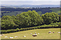
Farmland, Garway Hill
In the distance can be seen the familiar shape of May Hill.
Image: © Stuart Wilding
Taken: 6 Jul 2014
0.25 miles