IMAGES TAKEN NEAR TO
Pontrilas, HEREFORD, HR2 0BL
Introduction
This page details the photographs taken nearby to HR2 0BL by members of the Geograph project.
The Geograph project started in 2005 with the aim of publishing, organising and preserving representative images for every square kilometre of Great Britain, Ireland and the Isle of Man.

There are currently over 7.5m images from over14,400 individuals and you can help contribute to the project by visiting https://www.geograph.org.uk
Image Map
Images are licensed for reuse under creativecommons.org/licenses/by-sa/2.0
Notes
- Clicking on the map will re-center to the selected point.
- The higher the marker number, the further away the image location is from the centre of the postcode.
Image Listing (5 Images Found)
Images are licensed for reuse under creativecommons.org/licenses/by-sa/2.0
Image
Details
Distance
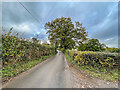
2
Field entrance
Field entrance off a lane east of Pontrilas.
Image: © Ian Capper
Taken: 24 Oct 2022
0.04 miles
3
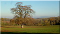
Isolated oak tree
In arable land to the west of Bagwyllydiart.
Image: © Jonathan Billinger
Taken: 29 Nov 2016
0.16 miles
4
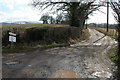
Track to Cobbler's Grove
Garway Hill with a light covering of snow can be seen on the horizon.
Image: © Philip Halling
Taken: 25 Feb 2006
0.18 miles
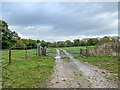
5
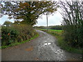
Track to Cobbler's Grove November 2011
The third example today where I quite randomly chose to photograph the same scene as Philip Halling five years later - Image
The Herefordshire Trail heads south at this point.
Image: © Jonathan Billinger
Taken: 17 Nov 2011
0.20 miles