IMAGES TAKEN NEAR TO
Pontrilas, HEREFORD, HR2 0BG
Introduction
This page details the photographs taken nearby to HR2 0BG by members of the Geograph project.
The Geograph project started in 2005 with the aim of publishing, organising and preserving representative images for every square kilometre of Great Britain, Ireland and the Isle of Man.

There are currently over 7.5m images from over14,400 individuals and you can help contribute to the project by visiting https://www.geograph.org.uk
Image Map
Images are licensed for reuse under creativecommons.org/licenses/by-sa/2.0
Notes
- Clicking on the map will re-center to the selected point.
- The higher the marker number, the further away the image location is from the centre of the postcode.
Image Listing (6 Images Found)
Images are licensed for reuse under creativecommons.org/licenses/by-sa/2.0
Image
Details
Distance
1
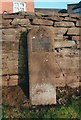
Old Milestone by the A465, Howton, Kenderchurch Parish
Carved stone post by the A465, in parish of KENDERCHURCH (0 District), Howton Farm, back to stone wall on cut-off old road. Hereford iron plate, erected by the Hereford turnpike trust in the 19th century.
Inscription reads:-
To
Hereford
10 Miles
Rivet on top, carved benchmark front mid top.
Milestone Society National ID: HF_HFAG10.
Image: © Robert Walker
Taken: 31 Jan 2012
0.04 miles
2
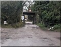
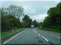
Low railway bridge, Howton, Herefordshire
Viewed from the A465. Headroom shown is 11' 6" / 3.5 metres.
Image: © Jaggery
Taken: 4 Dec 2022
0.06 miles