IMAGES TAKEN NEAR TO
Abbeydore, HEREFORD, HR2 0AQ
Introduction
This page details the photographs taken nearby to HR2 0AQ by members of the Geograph project.
The Geograph project started in 2005 with the aim of publishing, organising and preserving representative images for every square kilometre of Great Britain, Ireland and the Isle of Man.

There are currently over 7.5m images from over14,400 individuals and you can help contribute to the project by visiting https://www.geograph.org.uk
Image Map
Images are licensed for reuse under creativecommons.org/licenses/by-sa/2.0
Notes
- Clicking on the map will re-center to the selected point.
- The higher the marker number, the further away the image location is from the centre of the postcode.
Image Listing (3 Images Found)
Images are licensed for reuse under creativecommons.org/licenses/by-sa/2.0
Image
Details
Distance
1
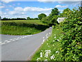
Country lane junction
Straight on towards Jury Bridge and The Cockyard, left to Kerry's Gate.
Image: © Jonathan Billinger
Taken: 26 May 2015
0.04 miles
2

Footpath this way
The signpost points the way across rolling Herefordshire countryside towards Wormbridge.
Image: © Jonathan Billinger
Taken: 26 May 2015
0.05 miles
3
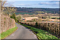
Towards Quarrels Green
Looking along the lane from Abbey Dore to Cockyard with Quarrels Green Farm in the centre of the photo.
Image: © Ian Capper
Taken: 25 Feb 2022
0.23 miles