IMAGES TAKEN NEAR TO
Bartestree, HEREFORD, HR1 4BP
Introduction
This page details the photographs taken nearby to HR1 4BP by members of the Geograph project.
The Geograph project started in 2005 with the aim of publishing, organising and preserving representative images for every square kilometre of Great Britain, Ireland and the Isle of Man.

There are currently over 7.5m images from over14,400 individuals and you can help contribute to the project by visiting https://www.geograph.org.uk
Image Map
Images are licensed for reuse under creativecommons.org/licenses/by-sa/2.0
Notes
- Clicking on the map will re-center to the selected point.
- The higher the marker number, the further away the image location is from the centre of the postcode.
Image Listing (26 Images Found)
Images are licensed for reuse under creativecommons.org/licenses/by-sa/2.0
Image
Details
Distance
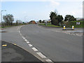
1
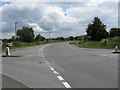
Bartestree - A438, Looking East From The Crossroads
Image: © Peter Whatley
Taken: 15 Jun 2009
0.03 miles
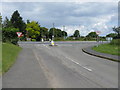
5
Phone box at the crossroads in Bartestree
Right to Longworth, left to Withington, straight on to Ledbury and Worcester.
Image: © Pauline E
Taken: 11 Mar 2008
0.11 miles
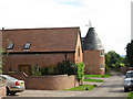
7
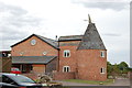
Converted Oast House at Bartestree
Round Kiln, with slate roof.The cowl looks to be in good condition.
Image: © Julian P Guffogg
Taken: 17 Aug 2011
0.11 miles
9

Timber outbuilding with corrugated roof
Next to the Gateway Centre in Longstone Lane, Bartestree.
Image: © Pauline E
Taken: 11 Mar 2008
0.11 miles
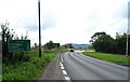
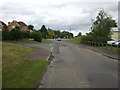
10
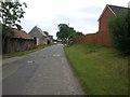
Longworth Lane, Bartestree, looking south
Image: © Rob Purvis
Taken: 21 Jun 2011
0.12 miles