IMAGES TAKEN NEAR TO
South Bank, HEREFORD, HR1 3SQ
Introduction
This page details the photographs taken nearby to South Bank, HR1 3SQ by members of the Geograph project.
The Geograph project started in 2005 with the aim of publishing, organising and preserving representative images for every square kilometre of Great Britain, Ireland and the Isle of Man.

There are currently over 7.5m images from over14,400 individuals and you can help contribute to the project by visiting https://www.geograph.org.uk
Image Map
Images are licensed for reuse under creativecommons.org/licenses/by-sa/2.0
Notes
- Clicking on the map will re-center to the selected point.
- The higher the marker number, the further away the image location is from the centre of the postcode.
Image Listing (25 Images Found)
Images are licensed for reuse under creativecommons.org/licenses/by-sa/2.0
Image
Details
Distance
1
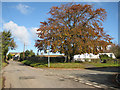
Magnificent beech, Southbank, Withington
The houses along Southbank are of 'Cornish' style.
Image: © Pauline E
Taken: 31 Oct 2008
0.04 miles
2
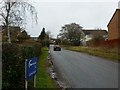
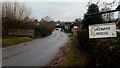
The Walk, Withington
Looking towards the village centre.
Image: © Jonathan Billinger
Taken: 10 Jan 2017
0.05 miles
4
A corner of Orchard House grounds
The house was once part of the care home property.
Image: © Jonathan Billinger
Taken: 23 Jan 2017
0.06 miles
5
White Stone Road
Looking south towards the junction with the Worcester Road.
Orchard House is a care/nursing home.
Image: © Jonathan Billinger
Taken: 31 Dec 2016
0.06 miles
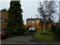
6
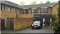
Orchard House
A care home mainly for local authority clients
Image: © Jonathan Billinger
Taken: 8 Jan 2017
0.06 miles
7
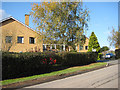
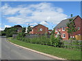
Orchard House, Withington
Residential care home in a modern building.
Image: © Pauline E
Taken: 31 Oct 2008
0.08 miles
8
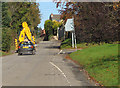
Not safe to pass
You're bound to meet farm traffic on narrow country roads and sometimes the odd bulldozer. If you're lucky, the driver will pull over, if not, you're stuck.
Image: © Pauline E
Taken: 31 Oct 2008
0.09 miles
9
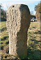
Old Guide Stone, A423, White Stone, Withington
A guide stone adapted from a wayside cross, with octagonal shaft and square top with chamfered edges; leaded holes that perhaps once held crosslets. The eroded lettering on three sides states: "This is the road to Hereford" , "This is the Road to Worcester", and a partial date of 17xx. Possibly originally a Roman milestone, near the Kenchester military road, inscribed LEG.
Grade II listed, List entry number 1180080 https://historicengland.org.uk/listing/the-list/list-entry/1180080
Milestone Society National ID: HF_HFWO04A
Image: © Milestone Society
Taken: Unknown
0.09 miles
10
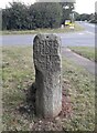
Old Guide Stone, A423, White Stone, Withington
A guide stone adapted from a wayside cross, with octagonal shaft and square top with chamfered edges; leaded holes that perhaps once held crosslets. The eroded lettering on three sides states: "This is the road to Hereford" , "This is the Road to Worcester", and a partial date of 17xx. Possibly originally a Roman milestone, near the Kenchester military road, inscribed LEG. See also https://www.geograph.org.uk/photo/6049199
Grade II listed, List entry number 1180080, https://historicengland.org.uk/listing/the-list/list-entry/1180080
Milestone Society National ID: HF_HFWO04A
Image: © Jan Scrine
Taken: 30 Mar 2021
0.09 miles